

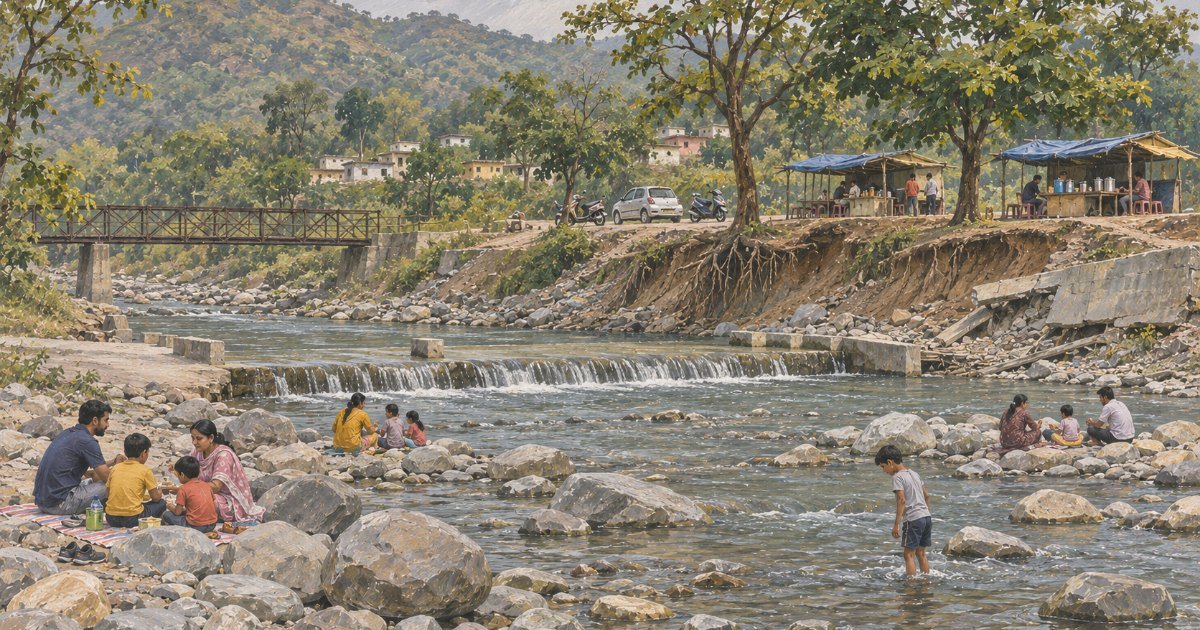
Maldevta is where Dehradun goes to stand in a river. It is twelve kilometres from the Clock Tower, it costs nothing to enter, and on a Sunday in May the causeway is a solid line of scooters, picnic mats and children in the shallows.
It is also the place where the Doon valley’s flood problem became impossible to ignore. On the night of 15–16 September 2025, the Song came down this valley carrying boulders, and when it receded it had taken a bridge, a stretch of road, a resort’s riverbank and 250 metres of the pipeline that supplies drinking water to two and a half lakh people. This guide is about both — the picnic and the flood — because at this particular place they are the same subject, and because anyone thinking of buying land on a river bank in Dehradun should read the second half before signing anything.
Quick answer: Maldevta is a free river spot on the Song, 11.7 km from the Clock Tower (about 15 minutes) and 5.6 km beyond Raipur. There is no ticket, no gate and no closing time; you park in the dust, walk down to a concrete causeway and sit on the boulders. It flooded catastrophically in September 2025 — the causeway, the road and Dehradun’s main water main all went — so avoid it during and after heavy rain, and never camp on the riverbed.
Last verified: 4 November 2026, against the Uttarakhand Irrigation Department’s Kalanga canal record, Times of India and PTI reports of 21–22 September 2025, Hindustan Times and The New Indian Express coverage of the same flood, Garhwal Post and Amar Ujala reports on the Maldevta road and the resort at Kisanpuri Bandawali, a 2026 Times of India report on the Sitapur bridge, and live Square Yards locality pages read the same day.
01At a glance
| What it is | A free river-access spot and picnic ground on the Song, at the village of Maldevta, with the canal headworks and a causeway across the river |
|---|---|
| Where | Maldevta, Raipur tehsil, Dehradun district — the road up from Raipur towards Sila |
| River | The Song, joined just above the village by the Bandal; the Kalali Gad from Sahastradhara joins at Kalinga hill |
| Distance from the Clock Tower | 11.7 km, 15 minutes (OSRM driving route, measured 4 November 2026) |
| Entry | Free. No ticket, no gate, no timings |
| Parking | Informal, on the road shoulder and the flat above the causeway; tea stalls charge nothing to park |
| Time needed | Two to three hours; half a day if you are picnicking properly |
| Best months | October to June. Avoid July to mid-September entirely |
| Watch out for | Flash floods, undercut banks, wet boulders, and a road that washes out most monsoons |
02What and where it really is
Drive out of Dehradun past Rajpur, up the Sahastradhara road as far as Raipur, and then turn north-east into the foothills. The tarmac narrows, the houses thin out, and within four kilometres you are in a valley that looks nothing like the city you just left: a wide, stony riverbed, hills on both sides covered in scrub and chir pine, and a village strung along the road above the water.
The river here is the Song. Above Maldevta it has already collected the Kalali Gad — the stream that comes down from Sahastradhara, the sulphur springs where the water is warm — which joins it about three kilometres below the springs at Kalinga hill. At Maldevta itself the Bandal comes in, and below the village the river turns south-west and runs down through Doiwala to meet the Suswa and eventually the Ganga at Raiwala.
The bed is what makes the place. This is a boulder river, not a sand river: the flood plain is a kilometre of rounded granite and quartzite cobbles, and in the dry months the water braids through them in channels a foot deep. The village sits on a terrace above it, which is the only reason the village is still there.
Maldevta is also, less romantically, a piece of water infrastructure. The Kalanga canal — the oldest irrigation system in the district — takes off from the Song here, and the headworks, the regulator and the canal’s first aqueduct are all within sight of the picnic crowd. That is the thread that runs through the rest of this guide: this is a place where a river is a picnic spot, a water supply and a flood, all at once.
03The name
Maldevta is the village, and the name is older than any of the tourism around it. The most commonly repeated reading — offered in The Statesman’s account of the place — is that mal referred to goods or minerals and devta to the deity of the spot, from the days when material was stored and moved along this valley. There is a shrine at the village, as there is at almost every village on this road, and local accounts attach the name to it.
Be careful with the spelling when you search. The forest and revenue records write Maldevta; travel sites sometimes write Maldeta or Maldevta with a doubled l; the Hindi is मालदेवता. Google Maps resolves all of them to the same pin, which is why the distance figures on different websites disagree so violently.
One clarification that matters more than the etymology: Maldevta is not a waterfall, and the small cascade that everyone photographs is a weir below the canal regulator, not a natural fall. It runs all year because the canal takes its water from the same reach.
04The canal, and why this village matters to the whole city
In 1855 the irrigation department of the North-Western Provinces began work on a canal to water the Doon valley’s eastern flank, and opened it in 1859–60. The head was on the Song near Raipur village — the intake that still serves Maldevta — and the canal ran south through the Raipur and Doiwala belt. In 1874–75, with the canal proving short of water in the dry months, the engineers tapped the Kalali Gad three kilometres above its confluence with the Song, which is why Sahastradhara’s springs have fed an irrigation canal for a century and a half.
The Kalanga system is now 101.09 km of distribution, serving more than 29 villages besides Dehradun city’s own demands, with the Kalinga aqueduct of 1859 still carrying it across the valley. It is a working nineteenth-century system, maintained by hand, and its headworks are the concrete structures at Maldevta that most visitors assume are part of the picnic arrangements.
The second piece of infrastructure is newer and less visible: Maldevta is where the city’s drinking water comes from. Dehradun’s main supply scheme draws on the Song here, and the pipeline that carries it to the city runs along this valley. In September 2025 that pipeline — including a British-era main beyond Maldevta — was destroyed by the flood, and 2.35 lakh people in the city went without piped supply until the department ran a temporary line.
05What you actually see
A wide stony riverbed, a concrete causeway low across it that you can drive over in the dry months, the canal regulator on the left bank with its sluice gates, and a scatter of tea stalls and snack carts on the flat above. On a good Sunday: families with mats and tiffin carriers, boys jumping off the causeway, a few cars parked nose-in to the water, someone’s speaker playing, and the smell of frying pakoras.
The water is clear and cold in winter, grey-green and loud after rain. The shallow channels between the boulders are ankle to knee deep and safe for children within sight; the main channel at the causeway is waist deep and has a current, and the pool below the weir is deeper than it looks.
Around it: the village on the terrace, the road climbing towards Sila, terraced fields on the far bank, and the hills behind. There is a small temple at the village end and the usual shrines; a couple of seasonal camps operate on the terraces in the cooler months, with tents and bonfires, and there are a handful of small resorts on the Raipur road that use the river as their selling point.
What there is not: no changing rooms, no toilets worth the name, no lifeguard, no lighting, no phone signal in parts of the bed, and no rubbish collection — which is why the far bank, out of sight of the road, is where the plastic ends up.
06Current condition: the flood, and what has been rebuilt
Three monsoons in a row have rewritten this valley, and the record is worth setting out in order.
In 2022 the original bridge across the Song at Maldevta was washed away. It was replaced by a causeway, which is what you drive over today — a low concrete apron designed to be overtopped, not to resist a flood.
Then came 15–16 September 2025. Sahastradhara recorded 192 mm of rain in a day and Maldevta 141.5 mm; the Song came down bank-high with a debris load, and the damage in this one valley was severe. Seven labourers were killed when a house collapsed near Chhamroli. A resort at Kisanpuri Bandawali, upstream, had diverted the river channel for four to five hundred metres and narrowed it, and when the flood arrived 150 metres of road was washed out; the district magistrate, Savin Bansal, ordered an inquiry into the diversion and put the damage at about ₹6 crore. The Raipur Chowk–Maldevta road lost 70 to 100 metres of carriageway at Keserwala. Dehradun’s main water supply line was breached, and the city’s supply had to be restored through a temporary arrangement. Across the district, PTI’s count by 22 September was 31 dead and three missing at nine locations, and the Times of India reported 766 drinking-water points damaged.
Temporary connectivity was restored within about two days, which is the part that deserves credit — the Public Works Department put a Bailey-style temporary crossing in and the village was reachable again. But a temporary crossing is not a bridge. The district magistrate inspected the causeway afterwards and directed the PWD to prepare a proper bridge proposal, and that proposal is the thing to watch: until a high-level bridge exists, every heavy monsoon will do this again.
It did it again in 2026. That August, the temporary hume-pipe bridge serving Sitapur was washed away and the Maldevta–Sila road was blocked; a new crossing was opened later the same month. This is now the pattern of the place: a road that works for ten months and a river that takes it apart in the eleventh.
07Practicalities
There is nothing to book and nothing to pay. That is the appeal and the problem: no gate means no closing time, no staff, no one to tell you the water is rising.
| Item | Detail |
|---|---|
| Entry | Free, all year, no ticket |
| Timings | None officially. Locally, daylight — leave by 5:30 pm |
| Parking | Road shoulder and the flat above the causeway; no fee, no marked bays |
| Food | Tea stalls and snack carts; nothing substantial, nothing after dark |
| Toilets | None. Plan accordingly |
| Mobile signal | Patchy in the riverbed; usable on the road |
| Swimming | Wading yes, swimming not advised; no lifeguard, no depth markers |
| Camping | Only with an operator on the terraces, never on the bed |
The one rule that matters. If it has rained hard in the hills in the last twelve hours, do not go down into the bed. This is a flashy catchment: the rain that floods Maldevta often falls ten kilometres away and arrives without warning on a blue sky. If the water turns brown, if you can hear boulders knocking together, or if the level starts climbing — get out and go uphill, not to the car. People have died in this valley doing the ordinary thing.
What to carry. Water, a mat, grip footwear for the boulders, a bag for your own rubbish, and cash for the stalls. The stones get hot enough by noon to burn bare feet, and the ones at the waterline are slippery with algae.
08How to reach
Route: Clock Tower → Rajpur Road → Sahastradhara Road → Raipur → Maldevta. The last stretch is single-lane hill road with a couple of blind bends; drive it in daylight the first time.
| From | Road distance | Drive time |
|---|---|---|
| Clock Tower, Dehradun | 11.7 km | 15 min |
| Dehradun railway station | 13.3 km | 20 min |
| ISBT Dehradun | 18.8 km | 28 min |
| Raipur | 5.6 km | 11 min |
| Sahastradhara | 6.5 km | 14 min |
| Jolly Grant airport | 26.5 km | 45 min |
These are measured on the OSRM routing graph from each point’s coordinates. The 15–18 km figures on travel sites are the longer approach through Rajpur village and are not wrong, only slower; the shortest route is the one above.
Buses and shared autos run from Rajpur to Raipur, and from Raipur there are shared jeeps up the Maldevta road in the morning and back in the evening — reliable for locals, awkward for a day trip. A taxi from the city is about twenty minutes each way, and most drivers will wait if you agree a return fare on the spot. There is no app-based cab service that will reliably come up here to collect you; plan the return before you go.
09Best time
| Season | What you get | The trade-off |
|---|---|---|
| October–November | Clear water, cool air, the bed scoured clean by the monsoon, no crowd | Short days, cold water, and a road that may still be under repair |
| December–February | Best light, best walking, empty riverbed, bonfire weather | Too cold to wade; morning fog on the Raipur road |
| March–June | The classic picnic: warm water, long evenings, everything open | Sunday crowds, 40°C on the stones by noon, litter at its worst |
| July–mid-September | Spectacular water, dramatic skies, nobody there | Genuinely dangerous, and the road may be shut. This is not the season to visit |
The best window is the fortnight after Diwali: the monsoon has drained, the water is clear and low, the boulders are dry, and the light on the far bank is the reason photographers come here. Go on a weekday, arrive by nine, and be off the bed by four.
10What the standard guides get wrong
- It is not a waterfall. Half the listings sell “Maldevta waterfall” with a photograph of a weir below the canal regulator. There is no natural fall here; what you see is a low barrage spilling, and in the dry season it is a trickle.
- The distance depends entirely on where you start. Listings give 12, 15, 16 and 18 km without saying from where. From the Clock Tower by the shortest route it is 11.7 km; if you go the long way through Rajpur village it is closer to 15. Quote the start point or the number is meaningless.
- “Camping on the riverbank” is not a thing you should do. Several pages describe pitching a tent on the bed. The bed is the flood channel; a camp there is a drowning waiting for a cloudburst ten kilometres upstream. Commercial camps on the terraces above are the real option.
- “Open all year” needs a qualification. The spot is open all year; the road is not. In September 2025 and again in August 2026 the Maldevta road was cut, and in 2022 the bridge went entirely. Check before you drive out in monsoon.
- The water is not “mineral-rich” in any useful sense. That line is copied from a nineteenth-century description of the canal’s irrigation water. Nobody has published a water-quality test of the bathing pools here, and upstream is a village, a road and a resort.
11What living near Maldevta is actually like
Nobody buys a house in Maldevta. What people buy is land on the Raipur–Maldevta road, and the price of it has been rising for a decade for one reason: it is fifteen minutes from Rajpur Road and it has a river.
| Type | Current range, October 2026 | Source |
|---|---|---|
| Residential plot, Raipur | ₹4,600–5,200 per sq ft (₹41,000–47,000 per sq yd) for 100–150 sq yd plots | Square Yards Raipur sale listings, last updated 15 Sep 2026 |
| Rent, 3 BHK furnished, Raipur | ₹35,000 a month for 1,400 sq ft | Square Yards Raipur rent listings, last updated 8 Oct 2026 |
| Rent, 2 BHK, Sahastradhara Road | ₹18,000–20,000 a month | Square Yards, same page |
| Rent, 2 BHK, Ladpur | ₹22,000 a month for 1,500 sq ft | Square Yards, same page |
| Riverside land, Maldevta road | No published locality rate — deals are private, and the price is a function of how close to the bed you are | No portal listing exists for the village; treat any broker figure as unverified |
Why people buy here. Raipur is the last settlement on the Sahastradhara road with a market, schools, a bus stand and a hospital within reach; beyond it the road becomes hill village. The river, the fields and the pine slopes are the amenity, and the Sahastradhara tourist traffic keeps a steady rental market for homestays and weekend houses.
What nobody tells you, and this is the honest part. Maldevta is the clearest case in the district of why riverside land is cheap. The 2025 flood took out a resort’s bank at Kisanpuri Bandawali, 150 metres of road, and the city’s water main; the district magistrate ordered an inquiry into the river diversion that the resort had built. Construction in a riverbed or on the active flood plain here is not merely risky, it is the thing the administration is now actively investigating. If a plot is described as “river-facing” and priced at a discount to the road, ask three questions: how high above the bed is the plinth, what happened on this land in September 2025, and does the seller have a copy of the demarcation. If the answers are vague, walk away — there will be another plot.
The practical downsides, in order of how often they will annoy you: the single-lane road with no footpath and no streetlights; water supply that depends on a canal headworks upstream that silts up; the monsoon fortnight when the road is cut and the village is served by a temporary crossing; and the fact that a river fifteen minutes from Rajpur Road is, on a Sunday, not a quiet river.
If you want this valley, buy on the Raipur side of the climb rather than at the bottom of it, and buy a plot with a road, a survey number and a wall — not a view. Listings across Raipur, Sahastradhara Road and the Rajpur belt are on the Doon marketplace, and a free account will email you when something new comes up in the locality you are watching.
12Frequently asked questions
Is Maldevta safe to visit?
Yes in the dry months, with the ordinary precautions: keep children out of the main channel, stay off the wet boulders, and leave before dark. It is not safe in monsoon or within a day of heavy rain in the catchment, when the river can rise without warning on a clear day.
How far is Maldevta from Dehradun?
11.7 km and about 15 minutes from the Clock Tower by the shortest route through Rajpur and Raipur. The 15–18 km figures online come from the longer approach through Rajpur village. From ISBT it is 18.8 km.
Is there an entry fee at Maldevta?
No. There is no gate, no ticket and no closing time, and the tea stalls do not charge for parking. That also means there are no toilets, no lifeguards and nobody to warn you about the water.
Can you swim at Maldevta?
People wade and splash in the shallow channels, and children paddle at the causeway. Swimming in the main channel is not advisable — there is a current, the pool below the weir is deeper than it looks, and there is no one on duty.
What happened at Maldevta in September 2025?
The Song flooded on the night of 15–16 September after 141.5 mm of rain in a day at Maldevta itself. Seven labourers died near Chhamroli, 150 metres of road was washed out at Kisanpuri Bandawali, 70–100 metres of the Raipur–Maldevta road went at Keserwala, and the city’s main water pipeline was breached.
Is the Maldevta road open now?
As of November 2026 the road is open and the causeway is in use, after the August 2026 repairs to the Sitapur crossing. It is a temporary arrangement, not a new bridge — expect closures after heavy rain until a permanent bridge is built.
Can you camp at Maldevta?
Only with an operator, on the terraces above the river. Pitching a tent on the riverbed is the single most dangerous thing visitors do here: the bed is the flood channel and a cloudburst upstream arrives with no warning.
Is Maldevta good for a family day trip?
Yes, and that is what it is for: free, close to the city, shallow water, stalls for tea. Take your own food, your own water, and a bag for your rubbish, and go on a weekday if you want the stones to yourself.
Which river is at Maldevta?
The Song, joined just above the village by the Bandal. The Kalali Gad from Sahastradhara comes in at Kalinga hill, about three kilometres below the springs, and the Song carries all of it down through Doiwala to the Ganga at Raiwala.
13Where to go next
The natural pairing is Sahastradhara, six and a half kilometres up the same road, where the Kalali Gad comes out of the limestone and the water is warm — the same water you are standing in at Maldevta, an hour earlier in its journey. If you want the opposite kind of river day, Robber’s Cave is a stream that vanishes into a gorge instead of spreading across a bed.
For the city, start at the Clock Tower and the market around it, walk Paltan Bazaar for the shopping, and read FRI if colonial architecture is the reason you came to Dehradun. Tapkeshwar Mahadev took the same September 2025 flood and is the other place in this valley where the river and the town are inseparable.
And if the flood section of this guide changed how you think about riverside land, the marketplace is where to look at what is actually for sale — with the locality, the plot size and the asking price written down, rather than described over a phone.
Last verified: 4 November 2026. Flood figures are from PTI and Times of India reporting of 21–22 September 2025 and Garhwal Post’s coverage of the road restoration; canal history is from the Uttarakhand Irrigation Department’s Kalanga record; distances are measured on the OSRM driving graph; property figures are from Square Yards locality pages read on 4 November 2026 and will move.
0 Comments
No comments yet — be the first to share your thoughts.