

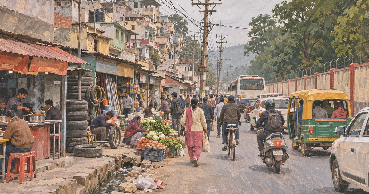
Prem Nagar is the other Dehradun: the one that grew up around an institution and a refugee camp, not around a parade of shops and a coffee roaster. It sits at the western mouth of the valley, where the Doon narrows towards the Chakrata hills, and it is dominated by two things that have nothing to do with property — the Indian Military Academy, whose 1,400 acres run north and south of the highway, and the memory of 1947, which is still visible in the way the land is held.
That combination produces the cheapest rents in the city and one of its most confusing property markets. A two-bedroom builder floor asks Rs 10,000 a month, and a plot 200 metres away asks Rs 25.5 lakh — but the same locality also has houses asking Rs 2.5 crore and a new 800 sq ft flat at Rs 8,800 a sq ft. Prem Nagar is not one market. It is a cantonment belt, a refugee settlement, a hill-road bazaar and a set of new colonies stacked on top of one another along seven kilometres of Chakrata Road.
This guide is about which one you are standing in, and what the standard descriptions of the place get wrong.
Quick answer: Prem Nagar is west Dehradun’s main locality, strung along Chakrata Road (NH-72) around the Indian Military Academy, PIN 248007. It is 8.2 km from the Clock Tower on the OSRM routing graph (about 8 minutes) and 10 km from the railway station. Rents run from Rs 8,000 to Rs 31,000 a month, plots from Rs 25.5 lakh, and houses up to Rs 2.5 crore. There is no railway station in Prem Nagar, and only parts of it fall under the cantonment board.
Last verified: 9 November 2026, against live Magicbricks and Square Yards listings read that day, the Times of India’s reports of 15 February 2026 and 28 July 2026, The Hindu’s and the Hindustan Times’ reports of the July 2026 bridge collapse, The Statesman’s 2018 report on the locality’s name, The Tribune’s account of Partition refugees near the IMA, and road distances measured on the OSRM routing graph.
01At a glance
| What it is | A west Dehradun locality spread along Chakrata Road around the Indian Military Academy, with a Partition-era refugee colony at its core and newer colonies on its slopes |
|---|---|
| Where | Prem Nagar, Dehradun district, Uttarakhand 248007 — on NH-72, west of the city centre, towards Nanda Ki Chowki and the Chakrata road |
| Distance from the Clock Tower | 8.2 km, about 8 minutes on the OSRM routing graph (measured 9 November 2026) |
| Known for | The Indian Military Academy, the Premnagar market, the bridge at Nanda Ki Chowki, and some of the lowest rents in Dehradun |
| Houses and flats on sale | Rs 50 lakh to Rs 2.5 crore on Magicbricks; flats from Rs 40 lakh; a new 800 sq ft two-bedroom at Rs 88 lakh |
| Plots on sale | Rs 25.5 lakh to Rs 42.5 lakh, November 2026 |
| Rents | Rs 8,000 to Rs 31,000 a month, with one furnished three-bedroom asking Rs 45,000 |
| Nearest railway station | Dehradun, 10.0 km and about 12 minutes — there is no station in Prem Nagar itself |
| Administration | Municipal corporation wards, with parts of the locality inside the cantonment board’s area |
| Best months to inspect | October to March; avoid the monsoon fortnight when the Nanda Ki Chowki road is being rebuilt |
02What and where Prem Nagar really is
Dehradun’s valley runs roughly east to west, and Prem Nagar occupies its western throat, where the Mussoorie ridge closes in from the north and the Chakrata road begins to climb. The Tons, the stream that drains this end of the Doon, crosses the road at Nanda Ki Chowki, a short drive further west. Everything about the locality’s shape follows from that geography: one main road, a market strung along it, colonies stacked on the slopes above and below, and a single bridge carrying all of it.
The Indian Military Academy is the reason the place exists at all. Its campus straddles the highway — the academy’s own history records NH-72 dividing it into a northern and a southern campus — and the wall runs for kilometres. The academy describes the campus today as about 1,400 acres. The land it started with in 1932 was the Railway Staff College’s estate, which the defence journal Salute puts at 155.53 acres and Wikipedia puts at 206 acres; the difference is the difference between the original transfer and the cantonment’s later acquisitions, and both figures get quoted as if they described the same thing.
South of the road, the ground falls away towards the Tons; north of it, the land rises towards the IMA’s training areas. It is not flat, and that matters practically: the slope is why drains run down to the road, why the lower-side basements flood first, and why the locality’s councillor describes garbage flowing downhill as a standing problem.
03The name
The obvious reading of Prem Nagar — “the abode of love” — is wrong, and the true one is more interesting. The locality is named after Rai Bahadur Prem Nath, a Dehradun figure who owned a cinema hall in the city, and The Statesman recorded the attribution in 2018 when it wrote about the area’s history. The market, the paper noted, flourished in the 1920s when construction of the Indian Military Academy and the Forest Research Institute brought labour and money to this end of the valley.
The spelling is unsettled in a way that matters for addresses. The revenue and postal record uses “Prem Nagar” as two words, which is what you will find on the pin code 248007 and on municipal notices; the older institutional usage, and much of the local speech, runs it together as “Premnagar”. Banks, schools and the market’s own shopfronts use both. For a property document, use the spelling on the seller’s title deed and check that the pin code on the deed is 248007 — a mismatch between “Prem Nagar” and “Premnagar” on two documents in the same chain is one of the small things that holds up a registration.
041932, 1941 and 1947
The academy arrived first. The Indian Military Academy was raised at Dehradun in 1932 on the Railway Staff College’s campus, and its first course of 40 gentlemen cadets passed out on 1 October 1932 — the date the academy still counts as its foundation. The market at Prem Nagar grew to serve it; the same 1920s boom that The Statesman describes also built the Forest Research Institute, a few kilometres east.
Then came the war, and a history that almost nobody in Dehradun talks about. From 1941 the British ran a Central Internment Camp at Prem Nagar for German and Italian civilians and prisoners of war, one of a handful in India. Its best-known inmate was the Austrian mountaineer Heinrich Harrer, who spent years in Dehradun’s camps before his escape to Tibet and the book that became Seven Years in Tibet. The camp’s huts and compounds are the reason the area had the infrastructure to absorb what came next.
What came next was Partition. In 1947 the camp was turned over to refugees arriving from what became Pakistan, and The Tribune’s account of the academy’s history records a camp of about 10,000 Sikh and Hindu refugees just down the road from the IMA. Many stayed. The land they were settled on was not given to them outright: it was held by the district resettlement office, and the families lived on it for decades without a title they could sell. The Times of India reported in 2015 that 2,900 Partition families in Dehradun were finally getting the chance to register property that had been allotted to them in 1947-48 — a gap of 67 years between arrival and ownership.
The consequences are still in the property market. In September 2018 a demolition drive removed more than fifty homes in Prem Nagar, and the reporting that followed described a locality split by Chakrata Road: refugee families and their descendants on one side, and on the other the beneficiaries of plots allotted in the 1990s under the state’s sterilisation programme, many of whom had bought and sold without documentation. Encroachment, in other words, is not a recent intrusion here. It is the shape the settlement took when 10,000 people were housed in a wartime camp and left to regularise themselves.
05What you actually see
Coming out from the city, the first thing you notice is that the road is doing three jobs at once. Chakrata Road at Prem Nagar is a national highway, a bazaar street and the only way to the villages beyond, and there is no footpath for most of its length. Shops open directly onto the carriageway: dhabas, tyre repairers, hardware, a line of vegetable sellers, the Premnagar market complex set back behind them. Buses and shared autos stop where they can. Pedestrians walk in the road because there is nowhere else to walk.
Behind that frontage the locality changes character within 200 metres. On the north side, the IMA’s wall and its long green verge; on the south, lanes that climb or drop to houses built one room at a time, some four storeys on a plot meant for one. Further west the new colonies begin — gated, plotted, advertised — as the road climbs towards Nanda Ki Chowki.
What is not there is as telling. There is no park worth the name, no proper bus terminal, no multi-speciality hospital inside the locality, and no railway station despite what half the internet says. The nearest thing to a civic centre is the market itself, and the nearest large green space is the academy’s, which you cannot enter.
06Current condition: the bridge, the bins and the footpath
The live story in Prem Nagar is the bridge at Nanda Ki Chowki, and it is a story about how long repair takes. The previous bridge over the Tons was damaged in September 2025, in the natural disaster that cut the Chakrata road, and a temporary replacement carried traffic for ten months. That temporary bridge was itself washed away on 12 July 2026 — the same day the repaired bridge and its new approach road opened to the public, at a combined cost of about Rs 16 crore.
Sixteen days later the approach road caved in. The Hindu reported on 28 July 2026 that torrential rain had washed away the soil beneath the newly built approach, that the bridge’s main structure was safe and intact, and that the district magistrate, Ashish Chauhan, had inspected the site with a team of technical engineers. The Congress party’s state unit made the arithmetic its attack line: a bridge repaired at Rs 16 crore that could not last 16 days. For anyone commuting west, the practical fact of the year is simpler — the road out of Prem Nagar has a single point of failure, and in 2026 it failed twice.
The second live issue is the one the locality’s own councillor keeps raising. The Times of India reported in February 2026 that garbage flows downhill into Prem Nagar as traffic piles up on Chakrata Road, with no footpaths for pedestrians, and quoted area councillor Anil Prasad Nautiyal on the state of the roads and the non-functional traffic signal at Nanda Ki Chowki. Parts of the locality, the same report notes, fall under the cantonment board rather than the municipal corporation — which is the administrative reason the mess is hard to fix: two authorities, one road.
07Practicalities
Prem Nagar is the one part of Dehradun where the paperwork matters more than the price. A large share of the housing stock sits on land that was allotted rather than sold — resettlement plots, sterilisation-programme plots, village land absorbed into the municipal area — and the chain of title on some of it runs through a register entry rather than a sale deed. Before you pay anything, ask for the khatauni and the latest parchi, and check that the plot’s recorded use is residential.
The second practical point is the commute, which is better than the distance suggests and worse than the map suggests. Eight kilometres to the Clock Tower is nothing; the problem is that every one of those kilometres is Chakrata Road, which is a bazaar for the first four, and that the return trip at 6 pm takes twice as long as the morning. For the IMA, the FRI and the western institutional belt the location is genuinely good. For anything east of Rajpur Road it is a daily crossing of the whole city.
The third is water and drainage. The locality’s slope means the upper lanes are fine and the lower ones take everything that runs off them; the councillor’s complaint about garbage flowing downhill is really a complaint about drainage. Ask a seller which side of the road the plot is on, and go back in the monsoon to look at the drain.
The fourth is that there is no railway station, whatever the listings say. The district’s seven stations — Dehradun, Harrawala, Doiwala, Raiwala, Kansrao, Rishikesh and Virbhadra — are all on the eastern side of the city, and Dehradun station is 10 km and about 12 minutes away by road.
08How to reach
Distances are road kilometres measured on the OSRM routing graph on 9 November 2026, from the Premnagar market. Note how the two obvious anchors diverge: the city centre is closer than the railway station, which is unusual in Dehradun and is the single most useful thing to know about commuting from here.
| From | Road distance | Driving time |
|---|---|---|
| Clock Tower, Dehradun city centre | 8.2 km | 8 min |
| Dehradun railway station | 10.0 km | 12 min |
| ISBT Dehradun | 9.0 km | 11 min |
| Jolly Grant airport | 32.7 km | 40 min |
| Forest Research Institute | 7.4 km | 12 min |
| Vasant Vihar | 4.2 km | 6 min |
09Best time
| Season | What you get | The trade-off |
|---|---|---|
| October–November | Clear air, the clearest view up the Chakrata road, and the best light for inspecting property | Festival traffic through the bazaar; the market street barely moves |
| December–February | Cold, bright mornings; the quietest months in the rental market | Fog in the early hours on the highway, and houses without heating |
| March–June | The peak season for posting-related rentals, and the best time for building work | Heat, dust from the road, and the pre-monsoon water shortage |
| July–September | The greenest the locality gets, and the honest season for checking drainage | The monsoon; the Tons rises, and the Nanda Ki Chowki road is the first thing to close |
10What the standard guides get wrong
- “Prem Nagar is near the railway station.” There is no railway station in Prem Nagar, and none within four kilometres of the market. The district’s seven stations are all on the eastern side of Dehradun; the nearest, Dehradun, is 10 km and 12 minutes by road. The confusion comes from the old Railway Staff College campus, which is now the IMA — a railway institution, not a railway line.
- One distance for the whole locality. Portals and listicles give “8 km from the city centre” or “10 km from the railway station” as though they were the same measurement. Both are right, and they are different anchors: 8.2 km from the Clock Tower, 10.0 km from the station, 9.0 km from the ISBT. The station is further away than the centre, which is the opposite of most of Dehradun.
- “Prem Nagar is a cantonment area.” Only parts of it are. The Times of India’s February 2026 report notes that parts of the locality fall under the cantonment board while the rest is municipal — and that split is the reason the road, the bins and the footpaths have two authorities and no owner.
- “The IMA campus is 206 acres” (or 155.53, or 1,400). All three figures are in circulation and they describe different things: the Railway Staff College estate transferred in 1932 (155.53 acres according to the defence journal Salute, 206 according to Wikipedia) and the academy’s campus today, which it describes as about 1,400 acres. Quoting the small figure as the campus is the commonest error; quoting 1,400 as the original grant is the second.
- “The cheapest property in Dehradun.” True of plots and rents, false of houses. A plot at Rs 25.5 lakh and a two-bedroom at Rs 10,000 a month are genuinely the bottom of the city’s market. But a new 800 sq ft flat at Rs 88 lakh prices at Rs 8,800 a sq ft, which is Dalanwala money, and houses here ask up to Rs 2.5 crore. The locality’s average hides a spread of twenty times.
11What living in Prem Nagar is actually like
The rental market is where Prem Nagar makes its case. Square Yards listed 21 properties in the locality on 10 October 2026, and the ordinary band ran from Rs 8,000 for a 450 sq ft single-room builder floor to Rs 31,000 for a furnished three-bedroom. Most of the stock is a builder floor or an independent house of 1,000 to 2,000 sq ft, and a two-bedroom at Rs 18,000 to Rs 22,000 is the middle of the market.
| What | Size | Monthly asking |
|---|---|---|
| 1 RK builder floor | 450 sq ft built | Rs 8,000 |
| 1 BHK builder floor | 500 sq ft built | Rs 10,000 |
| 2 BHK builder floor, furnished | 1,500 sq ft built | Rs 20,000 |
| 3 BHK house, semi-furnished | 2,200 sq ft built | Rs 30,000 |
| 3 BHK house, furnished | 2,300 sq ft built | Rs 45,000 |
Compare those rows with the same sizes in Vasant Vihar, four kilometres east, and the discount is roughly 30 to 40 per cent — the price of the commute and the address. That is the whole proposition: for a family posted to the IMA, the FRI or one of the western schools, Prem Nagar is where the housing allowance goes furthest, and the academy’s own employees and contractors are the backbone of the tenant pool.
Buying is a different and much messier market. Magicbricks carried plots from Rs 25.5 lakh to Rs 42.5 lakh on 9 November 2026, flats from Rs 40 lakh to Rs 1.05 crore, and houses from Rs 50 lakh to Rs 2.5 crore. A new two-bedroom of 800 sq ft at Rs 88 lakh is the top of the flat market and the clearest sign of what has happened here: new construction on the slopes is being priced like the rest of Dehradun, while the older stock on resettlement land still trades at a discount because its paperwork is harder.
| Type | Size | Asking price | Rate |
|---|---|---|---|
| Plot | Varies by lane | Rs 25.5 – 42.5 lakh | Land, not built area |
| Flat, older stock | Two to three bedrooms | Rs 40 lakh – 1.05 crore | From about Rs 4,000/sq ft |
| New flat | 800 sq ft built | Rs 88 lakh | Rs 8,800/sq ft |
| Independent house | 2,000 – 2,500 sq ft | Rs 50 lakh – 2.5 crore | Land plus structure |
The honest downsides are the ones the councillor lists. There is no footpath on the main road, so children walk to school in the carriageway. Garbage from the upper lanes ends up in the lower ones. The traffic signal at Nanda Ki Chowki has not worked, and the bridge approach has failed once already this year. And the documentation risk is real: buying on a resettlement plot is buying a legal position as much as a house, and a lawyer who knows the district resettlement register is not an optional expense.
What you get for accepting all that is space, price and proximity to the institutions that employ half the district. A 2,200 sq ft house at Rs 30,000 is not available anywhere east of here. Start with the marketplace to see what is listed in west Dehradun, and create a buyer account if you want new Prem Nagar listings as they appear. For the comparison that matters, read Raipur for the same road going east, and Selaqui for where the highway leads past the bridge.
12FAQ
Where exactly is Prem Nagar in Dehradun?
On Chakrata Road (NH-72) in the west of the city, around the Indian Military Academy, PIN 248007. It is 8.2 km from the Clock Tower and 4 km short of Nanda Ki Chowki, where the road crosses the Tons.
Is there a railway station in Prem Nagar?
No. There is no station in the locality and none within four kilometres of the market. Dehradun station, the nearest, is 10 km and about 12 minutes by road; the district’s seven stations are all on the eastern side of the city.
What is the pin code of Prem Nagar?
248007. Use that spelling — two words — on property documents and courier addresses, and check that the deed and the pin code agree.
Why is it called Prem Nagar?
After Rai Bahadur Prem Nath, a Dehradun figure who owned a cinema hall in the city, according to The Statesman’s 2018 account of the locality’s history. The literal reading, “abode of love”, is a coincidence, not the origin.
Is Prem Nagar a cantonment area?
Only partly. Parts of the locality fall under the cantonment board and the rest under the municipal corporation, which is why the road, the drains and the waste have two authorities. Check which one a specific plot is in before you buy.
How big is the Indian Military Academy campus?
The academy describes its campus as about 1,400 acres today. It was raised in 1932 on the Railway Staff College’s estate, which is put at 155.53 acres by the defence journal Salute and 206 acres by Wikipedia — the smaller figures describe the original transfer, not the present campus.
How much does it cost to rent in Prem Nagar?
Rs 8,000 to Rs 31,000 a month on the 21 listings Square Yards carried on 10 October 2026, with a two-bedroom builder floor at Rs 18,000 to Rs 22,000 and one furnished three-bedroom asking Rs 45,000. That is roughly 30 to 40 per cent below Vasant Vihar, four kilometres east.
Are the plots freehold?
Not all of them. Much of the locality’s housing sits on land allotted by the district resettlement office after Partition, or on plots regularised later, so the chain of title can run through a register entry rather than a sale deed. Ask for the khatauni and take legal advice before paying.
Is Prem Nagar a good place to live?
For a family working at the IMA, the FRI or the western schools, it is the best value in Dehradun: space, a low rent and a short commute. For anyone working east of Rajpur Road, the daily crossing of the city and the state of Chakrata Road outweigh the saving.
13Where to go next
The natural next read is the Forest Research Institute, 6.5 km east — the institution whose 1920s construction, along with the academy’s, created the market that became Prem Nagar. Clement Town is the useful comparison on the other side of the city: also a settlement with a wartime and post-Partition history, also cheap by Dehradun standards, and 12 km away with a very different road.
If you are following Chakrata Road rather than leaving it, Raipur is the next locality east and Selaqui is where the highway goes past the bridge. And for the city that all these distances are measured from, the Clock Tower is 8.2 km east.
And if the reason you are reading this is a house rather than a school catchment, the next step is not another guide — it is the marketplace, where west Dehradun is listed with the locality printed on every row.
Last verified: 9 November 2026. The 1932 foundation and the 1,400-acre campus description come from the Indian Military Academy’s own history; the 155.53-acre Railway Staff College figure from the defence journal Salute and the 206-acre figure from Wikipedia, both read on 9 November 2026. The naming, the 1920s market and Rai Bahadur Prem Nath are from The Statesman, 30 June 2018. The wartime internment camp, Heinrich Harrer’s internment and the transfer to Partition refugees are from Wikipedia’s Central Internment Camp and IMA articles and The Tribune’s account of the academy’s history. The 2,900 families and the 2015 property registration are from the Times of India; the 2018 demolition drive and the split along Chakrata Road from the Times of India’s reports of that year. The September 2025 washout, the 12 July 2026 reopening at about Rs 16 crore, the 28 July 2026 approach-road collapse and the district magistrate’s inspection are from The Hindu and the Hindustan Times. The February 2026 garbage and traffic report, councillor Anil Prasad Nautiyal and the cantonment split are from the Times of India. Sale and rent figures are from Magicbricks and Square Yards listings read on 9 November 2026. Distances were measured on the OSRM routing graph from OpenStreetMap data.
0 Comments
No comments yet — be the first to share your thoughts.