

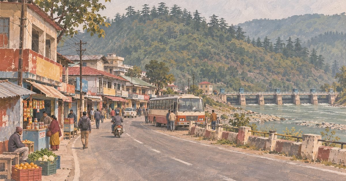
Vikasnagar is where the Doon valley stops being a valley. Forty kilometres west of the Clock Tower, the hills close in on both sides of the Yamuna, the road begins to climb towards Chakrata and Jaunsar, and the last flat land before Himachal holds a market town of 13,927 people with a court, a tehsil office and a bus stand that serves a hundred villages.
It is also the least understood town in the district, because almost everything written about it is about the barrage five kilometres away. Dakpathar gets the photographs and the hydroelectricity; Vikasnagar gets the students, the litigants, the mandi and the land market. The two are separate places with separate problems, and this guide is about the town.
The most useful thing to know about Vikasnagar in 2026 is that two large water decisions landed on it in the same season: the Yamuna’s worst flood summer in years, which forced the barrage gates open in July, and a six-state agreement in September to build the Kishau dam 45 km upstream. Both of them change what the ground here is worth.
Quick answer: Vikasnagar is a nagar palika town and tehsil headquarters in west Dehradun district, PIN 248198, 40 km from the Clock Tower (about 40 minutes) and 22.9 km from Paonta Sahib in Himachal Pradesh. It was renamed from Chauhadpur Nardidih in 1965 by Mahavir Tyagi after the Yamuna hydel projects transformed the area. Houses sell at about Rs 3,800 to Rs 4,700 a sq ft, a 4 BHK villa rents for Rs 35,000 a month, and the Dakpathar barrage is 5.3 km away.
Last verified: 10 November 2026, against the Census 2011 town tables and the state’s published list of urban local bodies, Wikipedia’s Vikasnagar and Dakpathar Barrage articles, the Union power ministry’s project document on the Yamuna hydel scheme, the Lok Bhavan press note of 4 July 2026, Down To Earth’s and The News Mill’s reports on the Kishau agreement of 15 September 2026, Amar Ujala’s report of 9 July 2026, live Magicbricks listings read that day, and road distances measured on the OSRM routing graph.
01At a glance
| What it is | A market town, nagar palika and tehsil headquarters at the western end of the Doon valley, near the Himachal Pradesh border |
|---|---|
| Where | Vikasnagar, Dehradun district, Uttarakhand 248198 — on the road to Paonta Sahib and Chakrata, 5.3 km from the Dakpathar barrage |
| Distance from the Clock Tower | 40.0 km, about 40 minutes on the OSRM routing graph (measured 10 November 2026) |
| Money and hours | No entry fee; no monument, no ticket. The barrage at Dakpathar is a working irrigation structure, not a visitor site |
| Time needed | An hour for the town and its mandi; a half day if you add Dakpathar and the Asan wetland |
| Best months | October to March. Avoid the monsoon: this is the flood reach of the Yamuna |
| Houses for sale | Rs 40 lakh to Rs 90 lakh on the live listings — Rs 3,813 to Rs 4,695 a sq ft |
| Houses for rent | A 3,000 sq ft four-bedroom villa at Rs 35,000 a month; two-bedrooms from about Rs 5,000 |
02What and where Vikasnagar really is
The Yamuna enters the Doon at Dakpathar, and Vikasnagar sits just above the point where the river leaves the hills for the plains. North of town the land rises into the Jaunsar-Bawar tract, terraced fields and deodar running up to Chakrata; south and west it drops towards Paonta Sahib and the Sirmaur dun. The town is on the hinge.
That hinge is why it is a tehsil headquarters. Courts, the tehsildar, the block office, the police station and the inter college are all here because a hundred villages on both sides of the ridge need one place to come to. It is also why the town has a permanent floating population of students and litigants, and why its rental market behaves differently from Dehradun’s: short stays, small units, cash rents.
The river is the other half of the geography. Vikasnagar is not on the Yamuna — that is Dakpathar’s privilege — but the river’s behaviour sets the town’s limits. The flood plain between them, and the low ground at Udiabagh and Rasulpur, take water whenever the barrage has to pass a spate. Everything built above that line is safe; everything below it is a calculated risk, and the calculation changed in 2026.
03The name
Vikasnagar is not an old name, and it is not a British one. The town was Chauhadpur Nardidih until 1965, when it was renamed by Mahavir Tyagi — then the Union Cabinet Minister for Rehabilitation, and the area’s member of Parliament — as Vikasnagar, the city of development.
The name was not marketing. After independence a chain of hydroelectric projects went in around the town — the Dakpathar barrage and the Dhakrani, Kulhal, Dhalipur and Chibro power houses — and the region’s economy, population and road network all changed with them. Tyagi’s argument, as the record has it, was that the new name described what had actually happened to the place. It stuck immediately.
Two spellings are in use: Vikasnagar, which is what the municipality, the pin code directory and the census use, and Vikas Nagar, which is what half the property portals use. The post office’s is the first. If you are searching for land records or listings, search both.
041949: Nehru’s barrage, and the town that followed
The dated history of modern Vikasnagar begins five kilometres north-east of it. The foundation stone of the Dakpathar barrage was laid on 23 May 1949 by Jawaharlal Nehru, and the scheme was commissioned in 1965 as the first stage of the Yamuna hydel works.
The structure is a concrete barrage across the Yamuna, 516.5 metres long and controlled by 25 floodgates, built to divert water into the East Yamuna Canal. The canal runs ten kilometres to the Dhakrani power house, where three 11.25 MW Kaplan turbines work on a 19.8-metre head for an installed capacity of 33.75 MW; four kilometres further on, the Dhalipur power house runs three 17 MW Francis turbines on a 30.48-metre head for 51 MW. Both were commissioned in 1965, and both work on a design discharge of 199 cubic metres a second.
The scheme did not stop there. The Asan barrage was built as the fourth stage and commissioned in 1975 — about 300 metres long, with a 4 km channel feeding the 30 MW Kulhal power house. Between them, the power channel from Dakpathar and the Asan diversion produce 114.75 MW, which is the figure the state’s own project documents use for the Yamuna valley works.
What that meant for Chauhadpur Nardidih was a labour force, a road, electricity and a market: the village on the Paonta road became the service centre for a construction programme that ran for two decades. The renaming in 1965 acknowledged a change that had already happened.
05What you actually see
A hill-road town with a plains economy. The main bazaar runs along the Paonta road: cloth, hardware, agricultural inputs, sweets, chemist shops, and the sort of kitchenware shop that sells pressure cookers and pickling jars to people from forty villages. There is a fruit and vegetable mandi, a grain market, the tehsil compound, a government hospital, and the bus stand where the Chakrata and Paonta buses load.
Up the side lanes the town turns residential fast: two- and three-storey concrete houses with small courtyards, the older ones with slate or CGI roofs, and the newer ones with a shop on the ground floor. There is no colonial quarter and no planned sector — the town grew along two roads and filled in behind them.
The sights are all outside. Dakpathar, with its barrage, gardens and the Yamuna running clear over stones, is 5.3 km. The Asan wetland and barrage are 12.5 km. Kalsi, with the Ashokan rock edict, is up the hill road. And Chakrata, the cantonment hill station, is the day trip everybody actually makes.
What is not there: no mall, no multiplex, no starred hotel, no private hospital of any size, and no industry inside the town. The industrial estate is at Selaqui, 20.8 km back towards Dehradun.
06Current condition: the flood, and the dam above it
Two events define Vikasnagar’s present, and both are about the Yamuna.
The first was the monsoon of 2026. On 9 July, with the river in spate after heavy rain, all the gates of the Dakpathar barrage were opened, sirens sounding, to pass the flow — Amar Ujala reported it from Vikasnagar that day. This is the routine that governs life on the flood plain here: a siren, then the gates, then water in the low colonies. The town itself sits above it, but the villages between the town and the barrage do not, and every summer the district administration moves people out of the lowest of them.
The second was on 15 September 2026, when six states — Uttarakhand, Himachal Pradesh, Uttar Pradesh, Haryana, Rajasthan and Delhi — signed the agreement for the Kishau multipurpose project on the Tons, a Yamuna tributary, in the presence of the Union home minister. The dam site straddles the Dehradun–Sirmaur border, about 45 km upstream of Dakpathar, which puts it in the upper reaches of this tehsil’s own river system.
The numbers matter and the sources disagree on some of them. Down To Earth describes a 232.6-metre concrete gravity dam; other reports say 236 metres. The News Mill gives 4×150 MW, while Swarajya reports 660 MW. What is not in dispute is the scale: about Rs 15,000 crore, with the Centre bearing 90 per cent of the water component’s cost, 1,324 million cubic metres of live storage, and some 2,950 hectares submerged across 17 villages and about 5,500 people, according to the 2020 feasibility study cited in the reporting.
For a property owner in Vikasnagar, that is a live question rather than a distant one. A dam 45 km upstream regulates the spates that force the gates open, which is good for the flood plain. It also puts a large construction programme, and a large displacement question, into the upper catchment of the same river. The project still has to go to the Union Cabinet.
The smaller, more immediate works are in the same press note as the rest of the district’s 2026 spending: on 4 July 2026 the state laid the foundation stone for the Dhalani canal in Vikasnagar development block at Rs 238.34 lakh, part of a Rs 219.29 crore package for Dehradun district.
07Practicalities
- Nothing to book. There is no entry fee anywhere in the town. The barrage at Dakpathar is an irrigation and power structure with restricted areas; you can see it, you cannot wander the gates.
- River safety. The Yamuna here is fast and cold, and the barrage releases water without much warning beyond the siren. Do not swim, and do not picnic on a sandbar in the monsoon.
- Roads. The Paonta road is good; the Chakrata road climbs and is slow. Buses to Dehradun run from the bus stand through the day, and the last one leaves early enough that a late return needs a car.
- Cash. There are ATMs in the bazaar, but the hill villages around the town are cash economies. Carry enough for the day.
- For land. Large parts of the tehsil are recorded as agricultural, and some of the river-adjacent land is gaon sabha or flood plain. Ask for the khatauni, the land-use classification and the tehsil’s flood-line note before paying a token.
- Winter. This is a valley-floor town at the mouth of a hill tract; December and January mornings are cold and fog sits on the Paonta road until mid-morning.
08How to reach
Distances are road kilometres measured on the OSRM routing graph on 10 November 2026 from the town centre. Note how far Vikasnagar is from everything on the eastern side of the district: it is 40 km from the Clock Tower and 64.4 km from the airport, which is the single most important line in any commute calculation here.
| From | Road distance | Driving time |
|---|---|---|
| Clock Tower, Dehradun | 40.0 km | 40 min |
| Dehradun railway station | 41.7 km | 43 min |
| ISBT Dehradun | 40.9 km | 43 min |
| Jolly Grant airport | 64.4 km | 72 min |
| Paonta Sahib, Himachal Pradesh | 22.9 km | 20 min |
| Dakpathar barrage | 5.3 km | 6 min |
| Herbertpur | 5.2 km | 7 min |
| Chakrata | 53.6 km | 55 min |
09Best time
| Season | What you get | The trade-off |
|---|---|---|
| October–November | Clear air, the river low and blue, and the best months for inspecting land | The post-monsoon state of the roads, and early fog on the Paonta road |
| December–February | Cold, bright days; the quietest rental market of the year | Fog until mid-morning, and houses built without heating |
| March–June | Warm and dry; the season for building and for paperwork at the tehsil | Heat on the valley floor, and dust |
| July–September | The river at its most dramatic, and the honest season for checking drainage and flood lines | The flood risk itself: gates open, sirens, and low colonies under water |
10What the standard guides get wrong
- “Chakrata is 45 km from Vikasnagar.” That is the line on Wikipedia and it is repeated everywhere. Measured on the routing graph from the town centre, it is 53.6 km and about 55 minutes — the road climbs through Kalsi and the last stretch is slow. Use the measured figure when you plan a day trip, and 45 km only if you are quoting the encyclopaedia.
- “Vikasnagar is in Himachal.” It is not; it is in Dehradun district, Uttarakhand, 22.9 km from the Himachal border town of Paonta Sahib. The confusion is understandable — Paonta is closer to Vikasnagar than Dehradun is, and the road, the trade and half the bus routes run that way — but it puts the town in the wrong state on a lot of aggregator pages.
- “Population 13,927.” That is the 2011 census figure for the nagar palika area of 9 wards, and it is now fifteen years old. It is still quoted as current. No post-2011 municipal count has been published that can be cited, so any number claiming to be today’s is an estimate.
- “Dakpathar dam.” It is a barrage, not a dam: 516.5 metres of gated concrete across the river, built to divert water into a canal, with a live storage that is a fraction of a reservoir’s. The distinction matters because a barrage passes floods rather than holding them — which is precisely why the gates open in a spate and why the flood plain downstream is still a flood plain.
- “A planned town built by the British.” Vikasnagar’s name, layout and growth are all post-1949. It was a village called Chauhadpur Nardidih until 1965, renamed for the hydel development around it. The neatness of the bazaar is a hill-road market, not a cantonment plan.
11What living in Vikasnagar is actually like
The market is small, cheap and unusually honest about itself. On 10 November 2026 Magicbricks carried nine or more resale listings under “Vikas Nagar”, and the two rows that reconcile cleanly set the band: a 1,917 sq ft three-bedroom in Jal Vayu Towers at Rs 90 lakh, which is Rs 4,695 a sq ft, and a 1,049 sq ft three-bedroom house at Rs 40 lakh, which is Rs 3,813 a sq ft.
The rest of the page needs reading carefully. One row offers a “5 BHK farmhouse” of 550 sq ft on Langha Road for Rs 3 crore — an area and a price that cannot both be true, and a location that is on the Dehradun side of the tehsil rather than in the town. That is the portal’s locality label doing what it always does: “Vikas Nagar” on Magicbricks is a polygon that stretches 20 km back towards the city, and the town proper is a small part of it.
| What | Asking price, November 2026 | Implied rate |
|---|---|---|
| 3 BHK flat, Jal Vayu Towers, 1,917 sq ft | Rs 90 lakh | Rs 4,695 a sq ft |
| 3 BHK house, 1,049 sq ft, resale | Rs 40 lakh | Rs 3,813 a sq ft |
| 4 BHK villa, 3,000 sq ft, rent | Rs 35,000 a month | Rs 11.7 a sq ft a month |
| 2 BHK house, 1,222 sq ft, Herbertpur (labelled Vikas Nagar) | Rs 12,000 a month | Rs 9.8 a sq ft a month |
Two things stand out. First, the capital values are roughly the same as Doiwala’s and about half of Dehradun’s city localities: Rs 3,800 to Rs 4,700 a sq ft for a built house is what a small western town costs, and it has been stable. Second, the rental market is dominated by small units — two-bedroom houses of 400 to 500 sq ft at Rs 5,000 to Rs 9,000 — which is what a court town with students and short postings produces. The Rs 35,000 villa is the top of the market, not the middle of it.
Who buys here: government employees posted to the tehsil, families from the surrounding villages moving in for the college and the hospital, Paonta-side traders who want an Uttarakhand address, and a few Dehradun buyers taking a second home near the river. Who should not: anyone whose job is east of Rajpur Road, because 40 km each way on a two-lane road is a different life.
The downsides are the flood plain, the distance, and the fact that the town’s economy is administrative rather than industrial. There is no mill, no estate and no employer of scale — Selaqui’s factories are 20.8 km away, and most of the town’s employment is the tehsil, the courts, the schools and the mandi. Water supply is municipal and patchy in the outer lanes. And the medical college hospital is in Dehradun, 41.7 km away.
What you get for it is the cheapest habitable land in the district that still has a court, a college and a bus stand, with Himachal twenty minutes away and the river five kilometres off. Start with the marketplace to see what is listed in the western tehsils, and create a buyer account if you want Vikasnagar listings as they appear.
12FAQ
Where exactly is Vikasnagar?
At the western end of the Doon valley in Dehradun district, Uttarakhand, 40 km from the Clock Tower and 22.9 km from Paonta Sahib in Himachal Pradesh. Pin code 248198; it is a nagar palika and the headquarters of Vikasnagar tehsil.
How far is Vikasnagar from Dehradun?
40.0 km and about 40 minutes to the Clock Tower, 41.7 km to the railway station and 40.9 km to the ISBT, measured on the routing graph. Jolly Grant airport is 64.4 km.
Why is it called Vikasnagar?
Because it was renamed for the development around it. The town was Chauhadpur Nardidih until 1965, when Mahavir Tyagi — then Union Cabinet Minister for Rehabilitation and the area’s MP — renamed it after the Dakpathar barrage and the Dhakrani, Kulhal, Dhalipur and Chibro power houses transformed the region.
Is Vikasnagar the same as Dakpathar?
No. Vikasnagar is the town; Dakpathar is 5.3 km away and is the site of the barrage and its power houses. People use Dakpathar for the river and the gardens, and Vikasnagar for the court, the market and the bus stand.
Does Vikasnagar flood?
The town sits above the flood line; the low ground between it and the barrage does not. In July 2026 all the gates of the Dakpathar barrage were opened with sirens sounding to pass a spate, and the colonies on the flood plain are moved out most monsoons. Check the flood line for any plot near the river.
What is the Kishau dam and does it affect Vikasnagar?
It is a multipurpose dam on the Tons about 45 km upstream of Dakpathar, agreed by six states on 15 September 2026 at an estimated Rs 15,000 crore, with the Centre bearing 90 per cent of the water component. It would regulate flows on this reach; it also submerges about 2,950 hectares across 17 villages, and still needs Union Cabinet approval.
What does property cost in Vikasnagar?
About Rs 3,813 to Rs 4,695 a sq ft for built houses on the November 2026 listings — a 1,049 sq ft three-bedroom at Rs 40 lakh and a 1,917 sq ft flat at Rs 90 lakh. Rents run from about Rs 5,000 for a two-bedroom to Rs 35,000 for a 3,000 sq ft villa.
How far is Chakrata from Vikasnagar?
53.6 km and about 55 minutes on the routing graph, though Wikipedia’s 45 km figure is the one usually quoted. The road climbs through Kalsi, so allow more time than the distance suggests.
Is Vikasnagar a good place to buy land?
It is the cheapest part of the district with a court, a college and a bus stand, and capital values have been flat rather than falling. The risks are land use — much of the tehsil is recorded agricultural — and the flood plain. Get the khatauni and land-use classification first.
13Where to go next
The obvious next read is Kalsi, up the hill road from here, where the Ashokan edict is carved into a rock beside the Yamuna — the oldest dated thing in the district. The Asan conservation reserve, 12.5 km away, is where the Asan meets the Yamuna and the best birding in the Doon.
For the corridor back to the city, Selaqui is 20.8 km east and the district’s industrial estate, Prem Nagar is where the road rejoins the city, and Raipur is the comparison on the eastern side of Dehradun. Vasant Vihar and the Clock Tower are the city anchors every distance here is measured against.
And if the reason you are reading this is land rather than a day out, the next step is the marketplace, where the western tehsils are listed with the locality printed on every row — which, given how far the portals’ “Vikas Nagar” polygon stretches, is the only way to be sure you are looking at the town.
Last verified: 10 November 2026. The 2011 population of 13,927, the 9 wards and the household count are from the Census 2011 town tables and the state’s published urban local body schedule. The renaming from Chauhadpur Nardidih in 1965 by Mahavir Tyagi, and the reference to the Dakpathar barrage and the Dhakrani, Kulhal, Dhalipur and Chibro power houses, are from Wikipedia’s Vikasnagar article, corroborated by the Uttarakhand tourism listing for the town. The barrage’s 516.5-metre length, 25 gates, the foundation stone of 23 May 1949, the 1965 commissioning, the Dhakrani and Dhalipur capacities, heads and turbines, the 199-metre design discharge, and the Asan barrage of 1975 with the 30 MW Kulhal plant, are from Wikipedia’s Dakpathar Barrage article and the Union power ministry’s project document on the Yamuna hydel scheme, both read on 10 November 2026. The 9 July 2026 gate opening is from Amar Ujala’s report. The Kishau agreement of 15 September 2026, the dam height of 232.6 metres, the 1,324 million cubic metre live storage, the 2,950 hectares and 17 villages, are from Down To Earth’s report of 17 September 2026; the 4×150 MW capacity and the 45 km upstream location from The News Mill’s report of 16 June 2026; the 660 MW figure and the Rs 15,000 crore cost from Swarajya’s report of 17 June 2026, where the two capacities are given differently and both are stated here. The Dhalani canal at Rs 238.34 lakh is from the Lok Bhavan press note of 4 July 2026. Sale and rent figures are from Magicbricks listings read on 10 November 2026, including the rows whose stated area and price do not reconcile. Distances were measured on the OSRM routing graph from OpenStreetMap data.
0 Comments
No comments yet — be the first to share your thoughts.