

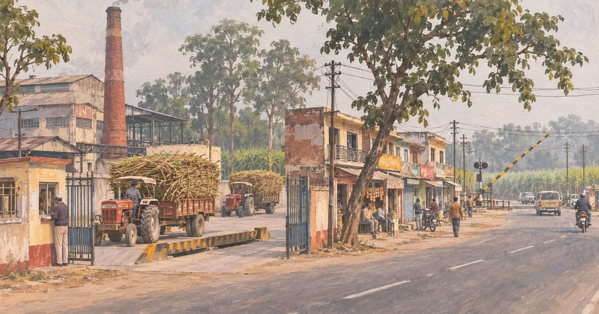
Doiwala is the town Dehradun built to process its cane and then forgot to describe. Twenty kilometres east of the Clock Tower, where the valley floor flattens towards the Haridwar plain, it exists because a sugar mill was planted there in 1930 and because the railway to Haridwar already ran through it. Everything else — the bazaar along the highway, the mill colony, the truck yards, the grain merchants — hangs off those two facts.
It is also the most mis-described town in the district. The standard pages say it is a “nagar panchayat” of 7 wards with 8,709 people, in the hills, with sub-zero winters. Three of those claims are out of date or wrong: it is a nagar palika parishad of 20 wards, it sits at 484 metres on the plain edge, and 8,709 is the 2011 count of a smaller boundary.
What is actually true is more useful: Doiwala is where the district’s sugar economy, its airport and its elephant corridor all meet, on a highway that carries more traffic than it was built for.
Quick answer: Doiwala is a nagar palika parishad town in Dehradun district, PIN 248140, on the Dehradun–Haridwar highway 19.8 km from the Clock Tower (about 20 minutes) and 6.8 km from Jolly Grant airport. It is built around the Doiwala Sugar Company mill, established in 1930 and rebuilt at 2,500 tonnes of cane a day in 1989-90, which crushed 18.60 lakh quintals in the 2025-26 season. There is no entry fee and nothing to queue for: this is a working town, not a sight.
Last verified: 10 November 2026, against the Uttarakhand Co-operative Sugar Factories Federation’s own history of the mill, the Union food ministry’s state-wise cane payment statement of 18 June 2026, the Lok Bhavan press note of 4 July 2026 listing 51 Dehradun projects, the district administration’s page for Nagar Palika Doiwala, the Census 2011 town tables, Wikipedia’s Doiwala and Doiwala railway station articles, Times of India reports from 2026, live Magicbricks listings read that day, and road distances measured on the OSRM routing graph.
01At a glance
| What it is | A sugar-mill and market town on the Dehradun–Haridwar highway, and the tehsil headquarters for the eastern Doon |
|---|---|
| Where | Doiwala, Dehradun district, Uttarakhand 248140 — nagar palika parishad office at Ward 1, Ambedkar Nagar |
| Distance from the Clock Tower | 19.8 km, about 20 minutes on the OSRM routing graph (measured 10 November 2026) |
| Money and hours | No entry fee, no ticket, no closing time — it is a town. The mill is a working factory, not a visitor attraction |
| Time needed | An hour for the bazaar and the mill gate; half a day if you are also going to Lacchiwala or the airport |
| Best months | November to March — the crushing season, when the mill is running and the air smells of gur |
| Houses for sale | Rs 1 crore to Rs 1.85 crore on the four listings Magicbricks carried on 10 November 2026 |
| Houses for rent | One listing that day: a 3,000 sq ft three-bedroom at Rs 18,000 a month plus Rs 5,000 maintenance |
02What and where Doiwala really is
The Doon valley is a trough between the Shivaliks and the Mussoorie ridge, and it drains east. Doiwala sits near the eastern lip of that trough, at 484 metres, where the hills pull back and the land opens into the Terai — the belt of sal forest, cane fields and spring-fed streams along the foot of the mountains.
That position explains everything about the place. Cane needs flat, irrigated, alluvial land, and the land east of Dehradun is exactly that. A factory here can draw cane from the Doon, from the Terai towards Haridwar and from the Sahaspur belt without any of it travelling more than a morning. The same flatness gave the railway an easy alignment, and later gave the airport — Jolly Grant, 6.8 km east — a 2,140-metre runway on ground that needed no cutting.
The town is not one settlement. There is the highway bazaar, strung along the Dehradun–Haridwar road with its grain merchants and tyre shops; there is the mill and its colony behind it; there is the railway station area; and then the villages that the municipality has swallowed — Nakraunda, Lachiwala, Bhaniawala, Lorhakhurd — which are still fields and orchards with a municipal boundary drawn around them. Doiwala’s 20 wards are mostly those villages plus the bazaar.
Doiwala’s 20 wards are mostly those villages plus the bazaar — which is why the price per square yard changes by a factor of three between the highway frontage and a colony three lanes back.
03The name
Doiwala is spelled Doiwala, Doiwal or, on some older maps, Doonwala. The local pronunciation is Doi-wala, with the stress on the first syllable.
The etymology in circulation — and it is in Wikipedia’s infobox — is that the place is named after “numerous objects made by wood sticks (Doi)”. A doi in the local dialect is a wooden implement, and a village that made or sold them would plausibly be the “place of dois”. An older version of the same article, still mirrored on several sites, says instead that it was named after a “British Ruler Doi”. There was no such ruler. That version should be treated as an error that has been copied forward rather than a competing tradition.
The honest answer is that the wooden-implement reading is a folk etymology with no documentary anchor. What the record does show is the spelling on paper: the district administration prints “Doiwala”, the pin code 248140 covers the town, and the railway station’s code is DWO.
041930: the mill, and then the town
Doiwala’s history is unusually well documented, because the mill that created it is still owned by the state and still publishes its own record. The Uttarakhand Co-operative Sugar Factories Federation’s account runs as follows.
The plant was established in 1930 with an open-pan boiling house, and converted to vacuum-pan boiling in 1933 — the step that turns cane juice into marketable crystal at scale. Capacity was raised to 900 tonnes of cane a day in 1963-64, once the UP State Electricity Board could supply power. The ownership then changed hands with a regularity that says more about the Indian sugar economy of the period than about Doiwala: it began as Laxmi Sugar Mills, became Vijay Sugar Corporation in 1940-41, went into liquidation in 1950 and was run afterwards as Janki Sugar Mills, a partnership.
The Central government managed it from 1956 to September 1962; the partners returned; a court-appointed receiver ran it for two years when they fell out; they came back in October 1966. Cane arrears brought a government receiver in February 1973, and from 1 February 1973 the UP State Sugar Corporation ran the mill, acquiring it outright on 28 October 1984.
Because the plant was obsolete and too small to be viable, the corporation built a new 2,500 tonne-a-day factory next to the old one, commissioned in 1989-90. When Uttarakhand was created on 9 November 2000, the unit passed to the new state on 16 January 2002 and became the Doiwala Sugar Company Limited, with its registered office in Doiwala. That is the mill that runs today, and its chimney is still the tallest thing in town.
The railway came earlier than the mill. Doiwala is a station on the Laksar–Dehradun line, now under the Northern Railway’s Moradabad division, with two platforms and a station code of DWO. The line is why the bazaar is where it is: the market grew at the point where the road crossed the rails, and the mill was then built beside both.
05What you actually see
A highway town, honestly described. The Dehradun–Haridwar road runs through the middle at an angle, and the bazaar is one long strip of two-storey shops with their goods out front: grain and pulses in open sacks, hardware, farm implements, sweets, tyre repair, and the eateries that feed the trucks. There is a bus stand, a government hospital, an inter college and the tehsil offices.
Behind it, the mill: a gate, a weighbridge, cane trucks queuing in season, a yard of bagasse, and the boiler stack. Nobody offers tours, and there is no ticket counter or visitor centre. Twice a year the town smells of molasses — during crushing, and again when the spent wash and press mud are moved.
What is not there is equally worth knowing. There is no mall, no multiplex, no hotel above the budget tier, and no restaurant worth a detour. There is no hill view: this is the plain. The sal forest and the elephant corridor are north and east of the town, along the Thano and Saat Mod roads, and the nearest thing to a sight is Lacchiwala, a spring-fed picnic spot in the same block, about eight kilometres away.
06Current condition: what changed in 2026
Three things happened to Doiwala in 2026, and all three are documented rather than rumoured.
The first is drainage. On 4 July 2026, at a Seva Pakhwada programme in Rishikesh, the governor and chief minister inaugurated and laid foundation stones for 51 projects worth Rs 219.29 crore across Dehradun district. Seven of them are in and around Doiwala, and the largest single item is flood protection along the Dulhani river — at Lakshman Siddh Colony, Nakraunda Road, Vivek Vihar, Vayu Vihar, Nirmal Colony, Vanasthalipuram and Delhi Farm — at Rs 412.70 lakh. The same list carries canal restoration in the Doiwala block at Rs 344.33 lakh (Chhidrawala, Khadri and Gularani), Rs 207.82 lakh for five minors including Shamshergarh and Harrawala, Rs 418.83 lakh in the Bullawala canal command, and 3.50 km of lined channel under the Miyanwala canal at Rs 205.12 lakh. Roads and civic works follow: the 5.20 km Dharkot–Ladwakot road at Rs 449.48 lakh, interlocking tiles in Lakshmipuram and Prayag Enclave at Rs 96.07 lakh, a large-animal veterinary hospital at Rs 625.40 lakh, and a cow shelter at Majri at Rs 489.04 lakh.
Read that list as a diagnosis. A town that needs Rs 4.13 crore of flood protection on one small river, and Rs 11.7 crore of canal restoration in one block, has a water management problem; the named locations are the ones that flood.
The second is the elephant corridor. In 2026 a 39-year-old woman, Anjali Gupta, was trampled to death by a wild elephant on the airport–Thano road in the Doiwala area; the Times of India reported it as the sixth fatal elephant attack in Uttarakhand that year, and quoted the divisional forest officer saying two drones and an extra team had been deployed, with Rs 3 lakh of a Rs 10 lakh ex-gratia paid. The same paper reported that a month after the chief minister promised a stakeholder dialogue on tree felling for the Rishikesh–Saat Mod and Thano road widening, the activists were still waiting — with Citizens for Green Doon arguing that the new alignment cuts the corridor.
The third is traffic. The stretch through the bazaar carries the district’s airport traffic, its Haridwar-bound traffic and its cane trucks on a road with no bypass. On a bad day it does not move.
07Practicalities
There is nothing to book, no entry fee and no opening hours, because this is a working town. What follows is what a visitor or a house-hunter actually needs.
- Getting off the highway. The bazaar has almost no parking; the side lanes behind it and the mill road do. Do not stop on the highway shoulder — it is a live lane with trucks on it.
- The mill. Doiwala Sugar Company is a factory under state ownership. There are no public tours, and the gate is a weighbridge, not an entrance.
- Water. Municipal supply is intermittent and the colonies behind the highway rely partly on bores. Any house you look at should be checked for a working bore and a tank, not just a connection.
- Wildlife. The Thano and Saat Mod roads north and east of town are elephant country. Nobody walks them after dark, and that is not superstition.
- Documents. Much of the land around the bazaar is still recorded as agricultural or as village abadi. Ask for the khatauni and check the land use before you pay anything.
08How to reach
Distances are road kilometres measured on the OSRM routing graph on 10 November 2026 from the town centre. Doiwala’s oddity is that the airport is closer than the railway station it sits beside — the station is in the town, the airport is six kilometres away.
| From | Road distance | Driving time |
|---|---|---|
| Clock Tower, Dehradun | 19.8 km | 20 min |
| Dehradun railway station | 19.6 km | 19 min |
| ISBT Dehradun | 22.0 km | 20 min |
| Jolly Grant airport | 6.8 km | 15 min |
| Rishikesh | 22.4 km | 21 min |
| Haridwar | 34.7 km | 39 min |
09Best time
| Season | What you get | The trade-off |
|---|---|---|
| November–February | The crushing season: cane queues, the mill running, the smell of gur, and the clearest air of the year | Cold mornings and heavy fog on the highway; the cane trucks slow everything down |
| March–April | The tail of the season, warm days, and the best light for looking at plots | Dust, and the start of the pre-monsoon heat |
| May–June | The quietest months; the mill is closed and the bazaar is bearable | Heat, and the water shortage that comes with it |
| July–September | Green fields and full streams; the honest season for checking drainage | The monsoon, and the Dulhani’s flooding — which is why Rs 4.13 crore of protection works were sanctioned in July |
10What the standard guides get wrong
- “Doiwala is a nagar panchayat of 7 wards with 8,709 people.” That is the Census 2011 line, and it is twelve years out of date on the first two points. The state’s own updated list of urban local bodies, published in November 2025, carries Doiwala as a Nagar Palika Parishad, and Wikipedia’s current article describes 20 wards with Narendra Negi as chairman. The 8,709 figure is a 2011 count of a smaller boundary, not today’s town.
- “20 km from Dehradun” is right, but it is measured from the wrong place. Twenty kilometres is the distance from the Clock Tower, and 19.8 km is what the routing graph gives. It is not 20 km from the railway station, and it is certainly not 20 km from the airport — the airport is 6.8 km from the town, which is the single most useful number about Doiwala and the one no listicle prints.
- “A hill station near Dehradun.” Doiwala is at 484 metres, on the plain edge of the valley, not in the hills. There is no view of the Doon from it and nothing to climb. The hills start north, up the Thano and Saat Mod roads, and that is also where the wildlife is.
- Old infobox weather claims. The mirrored versions of the Wikipedia article carry a winter minimum near freezing for Doiwala. That belongs to a hill town; a Terai-edge town at 484 metres has cold nights, not sub-zero ones, and no source fetched for this piece supports the colder figure.
- “The mill is closed.” It is not. The Union food ministry’s statement on cane prices, published 18 June 2026, records Doiwala crushing 18.60 lakh quintals in the 2025-26 season at 2,500 tonnes a day, producing 1.70 lakh quintals of sugar at 9.12 per cent recovery, with the cane price fully paid and a nil balance after the final payment on 27 February 2026. A closure rumour and a completed payment are not the same thing.
11What living in Doiwala is actually like
The property market here is thin, and saying so is more useful than a fake average. On 10 November 2026 Magicbricks carried four resale listings in Doiwala and one rental. The rental is a 3,000 sq ft three-bedroom house at Rs 18,000 a month with Rs 5,000 maintenance, posted at the end of August 2026 — which is a large house for the money, and about half what the same thing would cost in Dehradun city.
The sale listings need reading, not quoting. Magicbricks’ own price-per-square-foot arithmetic does not reconcile on three of the four: a 2 BHK shown at 1,500 sq ft and Rs 1.50 crore would be Rs 10,000 a sq ft, not the Rs 6,652 printed — unless you use the 2,255 sq ft in the description, which brings it back to the printed figure. The one row that reconciles exactly is a 318 sq yd (2,862 sq ft) three-bedroom at Rs 1 crore, and that is Rs 3,494 a sq ft.
| What | Asking price, November 2026 | Implied rate |
|---|---|---|
| 3 BHK house, 318 sq yd, semi-furnished, resale | Rs 1.00 crore | Rs 3,494 a sq ft |
| 2 BHK house, description says 2,255 sq ft | Rs 1.50 crore | Rs 6,652 a sq ft — the only basis on which the portal’s figure works |
| 6 BHK house, shown as 5,000 sq ft, new | Rs 1.85 crore | Rs 9,250 a sq ft on 2,000 sq ft, which is what the portal’s own arithmetic implies |
| 3 BHK house, 3,000 sq ft, semi-furnished, rent | Rs 18,000 a month, plus Rs 5,000 maintenance | Rs 6 a sq ft a month |
What that means in practice: built houses in the town proper sit between about Rs 3,500 and Rs 6,650 a sq ft depending on age and how far back from the highway they are. Plots are the bigger business and they are not on the portal — they move between local families, through the tehsil registry, at rates that depend mostly on frontage.
Demand comes from three directions: airport and airline staff, because Jolly Grant is six kilometres away; mill and government employees, because the town is the tehsil headquarters; and Dehradun buyers priced out of the city, who come for the Rs 3,500-a-sq-ft house and stay for the commute. Supply is constrained because most land around the bazaar is still agricultural, and conversion is slow.
The honest downsides are the ones the project list in section 06 spells out. The Dulhani floods the colonies behind the highway, which is why the state is spending Rs 4.13 crore on protection walls. The canals and minors silt, which is why Rs 11.7 crore of restoration is going into one block. The highway is a truck route with no bypass, and the elephant corridor means the land to the north is not developable in the way a map suggests. And the town has no significant private hospital or English-medium secondary school; for both, people drive to Dehradun.
None of that makes Doiwala a bad buy. It makes it a buy you underwrite on the mill, the airport and the road — three employers and one corridor — rather than on the view. Start with the marketplace to see what is listed east of the city, and create a buyer account if you want Doiwala listings as they come in.
12FAQ
Where exactly is Doiwala?
On the Dehradun–Haridwar highway, 19.8 km east of the Clock Tower, at 484 metres on the plain edge of the Doon valley. Post code 248140; the nagar palika parishad office is at Ward 1, Ambedkar Nagar.
Is Doiwala a nagar palika or a nagar panchayat?
A nagar palika parishad, with 20 wards. The Census 2011 tables describe it as a nagar panchayat of 7 wards, and that line is still repeated — it is out of date. The state’s urban local body list of November 2025 records it as a Nagar Palika Parishad.
Is the Doiwala sugar mill still working?
Yes. The Union food ministry’s cane-price statement of 18 June 2026 records 18.60 lakh quintals crushed in the 2025-26 season, 1.70 lakh quintals of sugar produced at 9.12 per cent recovery, and the cane price fully paid with a nil balance after 27 February 2026.
How far is Doiwala from Jolly Grant airport?
6.8 km, about 15 minutes on the routing graph — closer than the town is to Dehradun railway station. The airport was built in 1974 and its current terminal, opened in phases in 2021 and 2024 at about Rs 486 crore, covers 42,776 sq m and handles 3,240 passengers at peak.
Does Doiwala have a railway station?
Yes, on the Laksar–Dehradun line, station code DWO, with two platforms and an elevation of 484 metres. It is under the Northern Railway’s Moradabad division. The station is in the town; the airport is the bigger transport asset.
What is Doiwala’s population?
The 2011 census counted 8,709 people in the then nagar panchayat area. That boundary has since been expanded to 20 wards, so the current figure is higher, but no post-2011 municipal count has been published that can be quoted as fact.
Why is it called Doiwala?
The usual explanation is that it is the place of doi, the wooden implements made and sold here — a folk etymology with no documentary support. An older version of the same article claims a “British ruler Doi”, which is not a person who existed.
Is Doiwala safe for wildlife?
Not a question of safe — the Thano and Saat Mod roads north and east of town are an active elephant corridor. A woman was killed by an elephant on the airport–Thano road in 2026, the sixth fatal attack in the state that year. Do not walk those roads after dark.
Is Doiwala a good place to buy property?
For the price, yes, if your income is tied to the airport, the mill or the tehsil offices. Houses run about Rs 3,500 to Rs 6,650 a sq ft against double that in the city, and a 3,000 sq ft house rents for Rs 18,000. Check drainage, land use and the bore first.
13Where to go next
The nearest sibling guide is Lacchiwala, the spring-fed picnic spot in the same block — the one place east of Dehradun people drive out to on purpose. For the other end of the same road, the Clock Tower is where every distance here is measured from, and Raipur is the stretch between the city and here.
If you are following the highway rather than the town, Selaqui is the industrial answer on the western side of the district, and Prem Nagar and Vasant Vihar are the city localities most often compared with Doiwala on price.
And if the reason you are reading this is a house rather than a mill, the next step is the marketplace, where east Dehradun is listed with the locality printed on every row — which, on this road, is the only way to tell a Doiwala plot from a Bhaniawala one.
Last verified: 10 November 2026. The mill’s 1930 founding, 1933 vacuum-pan conversion, 900-tonne capacity of 1963-64, the succession of owners, the 1989-90 rebuilding at 2,500 tonnes a day and the transfer to Uttarakhand on 16 January 2002 are from the Uttarakhand Co-operative Sugar Factories Federation’s history of Doiwala Sugar Company. The 2025-26 season figures are from the Union food ministry’s cane payment statement of 18 June 2026; the July 2026 projects from the Lok Bhavan press note of 4 July 2026. The pin code is from the district administration’s page for Nagar Palika Doiwala; the 2011 population and 7 wards from the Census 2011 town tables; the 20 wards, chairman and railway station from Wikipedia; the 2025 urban local body list from the state’s published schedule. The elephant death and the Saat Mod widening are from Times of India reports of 2026; the airport figures from the Airports Authority of India as summarised on Wikipedia. Sale and rent figures are from Magicbricks listings read on 10 November 2026, and the price-per-square-foot inconsistencies in the table are the portal’s own. Distances were measured on the OSRM routing graph.
0 Comments
No comments yet — be the first to share your thoughts.