

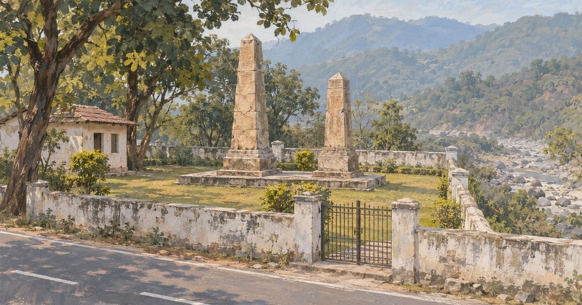
On the eastern edge of Dehradun, where the Sahastradhara road begins to climb and the city falls away behind you, there is a small walled garden with two weathered stone obelisks in it. Almost nobody stops. The traffic is going to the sulphur springs, the ropeway, the weekend; the garden is a hundred metres of lawn and a gate that is usually open.
It is the Khalanga war memorial, and it commemorates the first battle of the Anglo-Nepalese war — a month-long siege in October and November 1814 in which some 600 Gorkhali soldiers and their families held a half-built hill fort against a British force of 3,500 men with cannon, killed the British commander on the first day, and were beaten in the end not by firepower but by thirst.
The British built the memorial afterwards. That is the fact that makes the place strange and worth the stop: the victors put up a stone to their enemy, with his name misspelt on it, and left it standing for two centuries. This guide covers the siege, the two monuments people confuse, the walk up to the fort site, and the practical detail — starting with the fact that half the listings call it the Kalinga war memorial, which is a different war in a different state.
Quick answer: The Khalanga war memorial is at Tibbanala Pani on Sahastradhara Road, Dehradun 248013, 9.2 km and about 22 minutes from the Clock Tower on the OSRM routing graph. It is free, has no gate or published hours, and takes 20–30 minutes; the fort hill above it is another 20 minutes on foot. The siege ran from 31 October to 30 November 1814, Major-General Robert Rollo Gillespie was killed on the first day, and the garrison of about 600 broke out with 70 survivors. It is an Archaeological Survey of India monument.
Last verified: 6 November 2026, against Wikipedia’s Battle of Nalapani and Khalanga War Memorial articles, the Nepali Times retracing of the Khalanga siege, The Federal’s photo essay on the site, Times of India reporting on the Khalanga mela and the bicentenary, the Gurkha Museum’s account of the battle, live Magicbricks listings for Sahastradhara Road, and distances measured on the OSRM routing graph the same day.
01At a glance
| What it is | Two stone obelisks in a walled ASI garden, raised by the British after the 1814 siege of Nalapani — one to their own dead, one to the Gorkha commander |
|---|---|
| Where | Tibbanala Pani, Sahastradhara Road, Dehradun, Uttarakhand 248013 — on the valley side, below the fort hill |
| Distance from the Clock Tower | 9.2 km, about 22 minutes on the routing graph (measured 6 November 2026) |
| Entry | Free. No ticket, no counter, no guide fee |
| Timings | Daylight. Tourism listings quote 9 am–5 pm; there is no gate and no published timing |
| Time needed | 20–30 minutes at the memorial; add 30–45 minutes for the fort hill |
| Best months | October–March. The hill is hot and the undergrowth thick from April |
| Watch out for | No toilet, no water, no shop. The fort hill is a drinking spot and the ground is often littered |
02What and where it really is
There are two places here, about a kilometre apart as the crow flies, and most visitors only ever see the lower one.
The fort — the Khalanga outpost of Nalapani — sat on a hill of 150–180 m above the valley floor, north-east of the old city, with a tabletop top about 1.2 km long and its highest point at the southern end where the village of Kalanga stood. Nineteenth-century accounts describe it as steep on most sides and covered in dense jungle, which is why a garrison of a few hundred could hold it against a column. Nothing of the fort survives: the British razed it after the siege, and what is on the hilltop now is a tall column above overgrown foundations.
The memorial is downhill, on the valley side, on what is now Sahastradhara Road, beside the Rispana. The British put it there rather than on the hill: a pair of obelisks in a compound, one to Gillespie and his men, one to Balbhadra and his. That is the site with the signboard, the lawn and the caretaker, and it is the one the road passes.
Why here at all? Because in 1814 this was the frontier. The Doon valley had been under Gorkhali control since about 1804, when the Gorkha forces defeated and killed Pradyuman Shah of Tehri at Khurbura, and the valley was the easternmost of their gains before the British decided to push them back across the Kali. Dehradun was the first town in their path, and the hill above the Rispana was where the defence of it was made.
03The name
Khalanga is a Nepali military word. It means a barracks or a military post, and specifically one larger than a kot — the smaller hill fort. The word survives in half a dozen place names in Nepal, and it was the ordinary term for a garrison town. So “Khalanga war memorial” is not a place name in the way Dehradun is: it means “the memorial at the barracks”.
Nalapani is the hill and the village. The name is usually read locally as nala-pani, the water of the stream — the Rispana runs below it — and there is a folk telling, recorded by the Nepali Times, that the wind in the trees above the fort sounds like the dying garrison calling for water, pani, pani. That is folklore, not etymology, and the paper should be left where it is.
Kalinga is the mistake. A great many listings, and some newspaper copy, call this the “Kalinga war memorial” or the “Kalinga fort”. Kalinga is Ashoka’s war in Odisha, 2,000 km away and 2,300 years earlier; the resemblance is a mishearing of Khalanga, and it has stuck hard enough that even the bicentenary coverage in 2014 used it. If you are searching for the place, search Khalanga.
One more spelling, this one carved in stone. The obelisk inscription names the Gorkha commander as Bul Buddur — a British rendering of Balbhadra — and it is the reason the man appears under three or four spellings in the literature: Balbhadra Kunwar, Balbhadra Singh Thapa, Bulbudder, Bul Buddur.
04The siege, day by day
The war began badly for the British and this was the reason. Gillespie’s division — the 53rd Foot, about 2,500 native infantry, artillery and a few dismounted dragoons, 3,513 men in all — marched up from Meerut to take Dehradun, which the Gorkhalis had fortified under a young commander, Balbhadra Kunwar, then about 25 years old.
Balbhadra did not try to hold the town. He moved his force — roughly 600, including the soldiers’ families, who campaigned with them — up to the half-built fort at Nalapani, and waited. On 21 October, before war had even been declared, a British officer sent a summons to surrender at midnight. Balbhadra tore it up and replied that it was not customary to answer letters at such hours.
The first assault came on 31 October, a day before the formal declaration. The batteries opened at 600 yards and four columns went up the hill; only two of them moved on the signal, and both were cut down by the guns Balbhadra had placed along the wall, with arrows and stones from the rampart and, by the accounts, the women inside throwing missiles as well. Gillespie rode forward to rally the 53rd, reached about 30 yards from the gate, and was shot through the heart. The British withdrew with 32 dead and 228 wounded that day.
The second attempt, in mid-November, failed the same way. So the British changed method: they found the garrison’s water source — a spring a fifteen-minute walk below the fort — and cut it off on 27 November. Three days later, with the children crying for water and no reinforcement coming from Kathmandu, Balbhadra refused to surrender, took the 70 survivors, charged out through the besieging line and escaped into the hills. The British entered a fort of dead and dying men.
What the British did next is the reason there is a monument. They razed the fort, and then they built two obelisks for the enemy: one to Gillespie and the British and Indian casualties, one to Balbhadra with the inscription “Our brave adversary Bul Buddur and his gallant men”. Within a decade the Company was recruiting Gorkhas into its own army, and the reputation earned on this hill in November 1814 is the beginning of that story.
Balbhadra’s own end is usually got wrong. He went to Lahore and took service under Ranjit Singh; he was killed in 1823 in the Sikh–Afghan fighting. The Nepali Times’ account gives 1879, which is a typographical slip for 1823 rather than a different tradition — the man had been dead for half a century by then, and every other account puts his death in the 1820s.
05What you actually see
Two obelisks, four to five metres tall, of pale stone, on a low plinth, in a compound of mown grass. They are weathered and their lettering is worn; the inscription is legible in raking light and not otherwise. Around them: a low whitewashed wall, an iron gate, a couple of trees, a caretaker’s room, and a signboard that tells you what you are looking at in two languages and rather too few words.
The garden is small — you can walk it in three minutes — and it is on the valley side of the road, so the ground drops away behind it towards the Rispana and the city is spread out below. In the morning the light comes over the hill and the stone reads well; by four it is flat.
Up the hill, the fort site is a different experience: a rough road or a steep path, a tabletop of scrub and pine, foundations that look like rubble, and a tall column with three khukris on a black marble plinth. No interpretation, no railing, no path markings. On a Sunday it is a picnic spot, and the ground near the column carries the evidence of that.
What is not there matters too. No museum, no exhibits, no guide, no audio, no ticket office, no toilet block, no café, no shop selling anything. There is a war memorial in the full British imperial sense — a stone and a lawn — and nothing else has been built around it in 200 years.
06Current condition
The monument is under the Archaeological Survey of India and is maintained as a garden: the wall is sound, the grass cut, the obelisks stable, the gate in place. On the maintenance question the memorial is in better shape than most unprotected sites in the district, and it has been for years.
The pressure is not on the stone but on the hill. Reports from 2022 and 2023 describe the fort site as overgrown, littered and used for drinking — the Nepali Times found trash at the base of the column, and The Federal’s photo essay recorded broken bottles near the gate and a damaged iron gate, with the site committee talking about putting in steps to stop motorcycles riding up. A cleanliness drive at Khalanga by Gorkha youth organisations collected a reported 193 empty liquor bottles from around the monument. None of that has been fixed by a fence.
The community side is in better health. The Khalanga mela has run for more than fifty years: the 50th edition opened in December 2024 with a bike rally from Sahastradhara and prayers at the Chandranarayani temple, with the chief minister announcing a ₹5 lakh grant to the organising committee, and the 51st closed at Sagartal in Nalapani in November 2025 with the assembly speaker laying wreaths at the memorial. It is a Gorkha cultural event first and a tourist event second, which is why it works.
What has not changed is the setting. Sahastradhara Road is now a built-up corridor of apartments, schools and hotels, and the memorial sits in the middle of it, 9 km from the Clock Tower, with a housing society on one side and the stream on the other. In 1814 this was jungle above a frontier town. The road has done what roads do.
07Practicalities
Nothing to pay, nothing to book. The compound is open in daylight; tourism portals quote 9 am to 5 pm and that is as good a guide as any, but there is no gate to close and no published timing. Twenty minutes is enough for the memorial; the hill adds an hour if you walk it.
| Item | Detail |
|---|---|
| Entry | Free. No ticket counter and no guide to hire |
| Hours | Daylight, roughly 9 am–5 pm. No gate, no published timing |
| Photography | Allowed. The obelisks read best before noon; the inscription needs raking light |
| Time at the site | 20–30 minutes at the memorial, 30–45 more for the fort hill |
| Facilities | None. No toilet, no drinking water, no shop. Eat in Dehradun before or after |
| Accessibility | The garden is flat from the road. The fort hill is steep, unmarked and not a wheelchair route |
| What to carry | Water, a hat, closed shoes if you are walking up, and cash — nobody takes a card |
| Parking | On the road shoulder outside the gate. No car park |
Two cautions. The compound is a protected monument: do not climb the plinth, do not chalk or rub the lettering, and do not photograph children on the obelisks — the caretaker will object and he is right to. And the hill is a local picnic and drinking spot: broken glass near the column is normal, so keep to shoes and keep an eye on where you sit.
08How to reach
The memorial is on Sahastradhara Road, on the left going up, about a kilometre before the Sahastradhara car park. From the Clock Tower the route is Rajpur Road to the Sahastradhara turning at Kishan Nagar, then straight up the hill; the last stretch is the slow part, because it is a two-lane road with schools, colleges and a hospital on it.
| From | Road distance | Drive time |
|---|---|---|
| Clock Tower, Dehradun | 9.2 km | 22 min on the graph; allow 30–40 in school traffic |
| Dehradun railway station | 10.8 km | 25 min on the graph |
| ISBT Dehradun | 16.3 km | 29 min on the graph |
| Jolly Grant airport | 29.6 km | 50 min on the graph |
| Nalapani fort hill (from the memorial) | 4.0 km by road | 15 min by road, or 25–30 min on foot |
| Sahastradhara springs | 12.8 km further up the road | 31 min on the graph |
These are measured on the OSRM driving graph from each point’s coordinates, not copied from the tourism sites — which is why they disagree with the “5 km from the city” figure that most listings carry. The memorial is 9.2 km from the Clock Tower and 10.8 km from the railway station; the 5 km figure is the distance from Rajpur Road, not from the centre.
By bus, take any Sahastradhara Road service from the city and ask for Khalanga, or the Sahastradhara bus and walk back down; the stop is at the gate. An auto from the Clock Tower is the practical option — agree the fare before you get in, because the return leg is harder to find.
09Best time
| Season | What you get | The trade-off |
|---|---|---|
| October–November | Clear air, the mela season, cool mornings, the inscription sharp in low sun | The hill path is still wet from the monsoon and the undergrowth is high |
| December–February | The quietest and clearest months; the Doon haze lifts for a few hours most mornings | Cold, damp mornings; fog on Sahastradhara Road until nine |
| March–April | Warm, dry, long days; good light on the stone | Heat on the hilltop by eleven, and the scrub is tinder |
| July–September | The stream runs, the hill is green, no visitors at all | Leeches, mud, and a slick path; the garden is at its least photogenic |
The best single window is a weekday morning between late October and February, arriving before ten: the light is on the obelisks, the caretaker is there, and you will have the compound to yourself. If you want the mela, it falls at the end of November — but then you get a crowd, a stage and a speech, not a quiet stone.
10What the standard guides get wrong
- It is Khalanga, not Kalinga. Kalinga is Ashoka’s war in Odisha. Khalanga is a Nepali word for a military barracks, and it was the ordinary term for the garrison here. Listings, aggregator pages and some newspaper copy still say “Kalinga war memorial”, which sends readers to the wrong century and the wrong state.
- The distance is 9.2 km, not 5. Times of India and most listings say the memorial is 5 km from the city. Measured from the Clock Tower it is 9.2 km, and 10.8 km from the railway station. Five kilometres is roughly the distance from Rajpur Road, which is where the old city ended when the figure was first written down.
- The siege was a month, not six weeks, and the garrison had water for most of it. The dates are 31 October to 30 November 1814 — thirty-one days. The “six weeks without food or water” line, which appears in much of the press, compresses the whole siege into the last three days: the water supply was cut on 27 November, and the breakout came three days later.
- Wikipedia’s coordinate for the battle is about 6 km out. The article places the battle at 30.3929 N, 78.0854 E, which is north of the city near the Rajpur–Mussoorie road. The memorial is at 30.3426 N, 78.0983 E and the fort hill at 30.3342 N, 78.0978 E. Anyone navigating to the article’s pin ends up in the wrong valley.
- “The only memorial in history built by victors for the vanquished” is a claim, not a fact. Every article about the site repeats it, including the Archaeological Survey’s own superintendent in 2014, and no source is ever given. The obelisks are unusual and worth the visit on their own terms; the superlative is unverifiable and should be quoted as a claim.
- Balbhadra died in 1823, not 1879. He took service under Ranjit Singh after the war and was killed in the Sikh–Afghan fighting. The Nepali Times’ series prints 1879, which cannot be right: it is a slip for 1823, and the 1820s date is the one every other account gives.
11What living on Sahastradhara Road is actually like
The memorial is not in a village. It is 9 km from the Clock Tower on a road that has become one of Dehradun’s main residential corridors — apartments, schools, a hospital, the IT park at the top, and the springs at the end of it. If you are looking at property here, the thing you are buying is the road, the schools and the hill air, and the thing you are paying for is the last two kilometres of it.
Buying. These are asking prices on live Magicbricks listings for Sahastradhara Road, read on 6 November 2026. The per-square-foot column is arithmetic on the listing’s own price and area, not a portal average.
| Listing (live, 6 November 2026) | Size | Asking price | Per sq ft |
|---|---|---|---|
| 3 BHK builder floor, Sahastradhara Road | 1,260 sq ft | ₹85 lakh | ₹6,746 |
| 3 BHK apartment, Sangam Valley | 2,607 sq ft | ₹2.08 crore | ₹7,979 |
| 3 BHK apartment, The Downtown | 1,678 sq ft | ₹1.72 crore | ₹10,251 |
| 3 BHK penthouse, Pacific Eiffel Homes | 3,855 sq ft | ₹3.85 crore | ₹9,987 |
| 5 BHK penthouse, Pacific Golf Estate | 4,526 sq ft | ₹6.50 crore | ₹14,362 |
| Studio apartment, Hansmukhi Garden Estate | 450 sq ft | ₹32 lakh | ₹7,111 |
| Residential plot, ABL Panache Valley | 449 sq yd (4,041 sq ft) | ₹6.28 crore | ₹15,540 |
The spread is the story: ₹6,700–₹10,300 a square foot for a built apartment depending on age and view, ₹7,111 for a studio, and ₹15,540 for a plot inside a branded development at ABL Panache Valley. The penthouses at Pacific Golf are the top of the market at ₹14,362 a square foot, which is what a golf-course frontage and 4,500 sq ft of floor plate cost on this road. Nothing in that range is unusual for Dehradun in 2026 — Sahastradhara Road has been the city’s premium address for a decade, largely because of the schools and the IT park.
Renting. The rental market here is almost entirely furnished apartments in those same gated projects, priced for families posted to the city for two or three years. Live listings on 6 November 2026:
| Listing (live, 6 November 2026) | Size | Monthly rent | Per sq ft |
|---|---|---|---|
| 2 BHK, Sikka Kimaya Greens | 1,195 sq ft | ₹22,100 | ₹18 |
| 1 BHK, Pacific Golf Estate | 480 sq ft | ₹25,000 | ₹52 |
| 2 BHK, Doon Divine | 1,250 sq ft | ₹26,000 | ₹21 |
| 3 BHK, Sikka Kimaya Greens | 1,390 sq ft | ₹28,000 | ₹20 |
| 2 BHK, Pacific Golf Estate | 1,380 sq ft | ₹36,000 | ₹26 |
| 3 BHK, Sahastradhara Road | 2,200 sq ft | ₹55,000 | ₹25 |
| 4 BHK, Sahastradhara Road | 2,200 sq ft | ₹60,000 | ₹27 |
Rents run from ₹18 to ₹52 a square foot, which is a wider band than buyers see: the small 1 BHK is priced for a single tenant who wants the location and the security, and the per-foot number therefore looks absurd against the 3 BHKs. Maintenance is charged separately and varies by society, so two listing rents on the same road are not comparable without it.
Why anyone buys here. The road has the schools — Doon’s private-school belt starts at Kishan Nagar and runs up — the Max Hospital, the IT park at the top, and the springs and the forest as the weekend. It also has the only genuinely walkable hill air inside the municipal boundary. For a family moving to Dehradun from Delhi or Mumbai, this is where the estate agents take them first.
The honest downsides. Traffic on Sahastradhara Road is the worst in the city between 8 and 10 in the morning and 4 and 7 in the evening, and there is no footpath for most of it — you walk on the road, past open drains and shopfronts. Water supply in the upper reaches depends on tankers in summer; the municipal line is unreliable above the IT park. The hill is steep enough that the last kilometre of any walk is a climb. And in the monsoon the Rispana below the memorial runs high and dirty, the retaining walls on the road slip, and the springs — the reason the road exists — are at their least pleasant just when the tourists arrive.
Listings along the corridor are on the Doon marketplace; a free account will alert you when something appears on the road or above it.
12Frequently asked questions
Is the Khalanga war memorial free to visit?
Yes. There is no ticket, no counter and no guide to pay. It is an ASI-protected monument maintained as a garden, and the only staff you are likely to see is a caretaker.
What are the timings?
Daylight, roughly 9 am to 5 pm. Tourism listings quote those hours, but there is no gate and no published timing, so the practical limit is the light.
How far is it from Dehradun city centre?
9.2 km from the Clock Tower on the OSRM routing graph, about 22 minutes without traffic and 30–40 in school hours. It is 10.8 km from the railway station. The 5 km figure in the listings is measured from Rajpur Road.
Is it the same as the Kalinga war memorial?
Yes — that is the same place under a wrong name. Kalinga refers to Ashoka’s war in Odisha; Khalanga is a Nepali term for a military barracks, and it was the name of the Gorkhali outpost here.
Who fought at Nalapani?
A British East India Company division of 3,513 men under Major-General Robert Rollo Gillespie, against a Gorkhali garrison of about 600 under Balbhadra Kunwar, including the soldiers’ families. Gillespie was killed on the first day of the assault, 31 October 1814.
Can you visit the fort itself?
Yes. A rough road and a steep path lead up from near the memorial to the tabletop, where a tall column stands above the overgrown foundations. There is no interpretation, no railing and no entry charge, and the site is often littered.
How long does a visit take?
Twenty to thirty minutes for the memorial and its garden. Add thirty to forty-five minutes if you walk up to the fort site and want the view of the city.
Is there anything for children?
Not really. There are no exhibits, no museum and no facilities; the garden is a lawn with two stones in it. The hill is a climb with broken glass in places. It works as a history stop for a child who has been told the story first, and not otherwise.
When is the Khalanga mela?
At the end of November, over two days, at Sagartal in Nalapani — the 51st edition closed there on 30 November 2025. It is organised by the Balbhadra Khalanga Vikas Samiti with wreaths at the memorial, prayers at the Chandranarayani temple and a fair.
13Where to go next
The obvious pairing is Sahastradhara, 12.8 km further up the same road, where the limestone belt produces the sulphur springs the traffic is actually heading for. Do the memorial first, on the way up, and the springs second — that is the order that avoids the afternoon crowd.
If the military history is the point, the district’s other colonial set piece is the Forest Research Institute, whose greco-roman buildings were laid out a century later on the same side of the city; and Kalsi, four hours west on the Yamuna, carries the Mauryan rock edict that has nothing to do with Kalinga except the name people confuse it with.
Closer in, Robber’s Cave is the stream-and-canyon walk on the same side of town, Tapkeshwar Mahadev is the temple where a stream runs over the lingam, and Mindrolling Monastery is the other place in Dehradun built to be looked at rather than used.
For the city itself, the Clock Tower and Paltan Bazaar are where Sahastradhara Road begins, and Guru Ram Rai Darbar in Jhanda Mohalla is the other monument in the district that a community still uses as a living site rather than a ruin.
And if the property section made you curious about the road, the marketplace lists what is actually for sale along it, with the built area and the asking price written down.
Last verified: 6 November 2026. The siege dates, order of battle, the 3,513 men, the 150–180 m hill, the torn surrender letter, the 27 November water cut, the 70 survivors and the two obelisks with the “Bul Buddur” inscription are from Wikipedia’s Battle of Nalapani and Khalanga War Memorial articles, checked against the Nepali Times’ Khalanga narrative and the Gurkha Museum’s account; the 1804 Gorkha conquest of the Doon, the column with three khukris and the site’s condition are from The Federal’s photo essay; the mela editions, grants and the Chandranarayani temple are from Times of India reporting of 2024 and 2025; the etymology of khalanga as a barracks is from the Nepali-language usage recorded for Pyuthan; distances are measured on the OSRM driving graph; property prices are live Magicbricks listings for Sahastradhara Road read on 6 November 2026 and will change.
0 Comments
No comments yet — be the first to share your thoughts.