

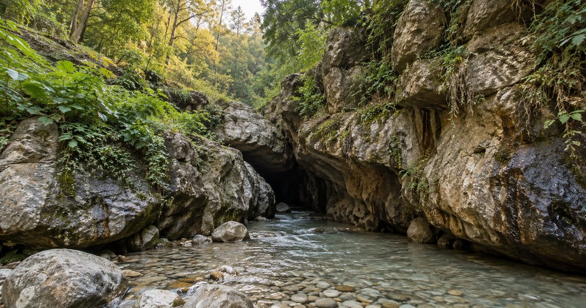
Robber’s Cave is the most misdescribed place in Dehradun. Every listing calls it a cave; the cave literature says it is not one, and has said so for fifty years. Half the guides promise a ten-metre waterfall inside it. Some describe a ruined fort wall in the middle of it. The name on the signboard is not Robber’s Cave at all — it is Gucchupani, and local people use that.
None of this is a reason to skip it. It is the best hour in Dehradun on a hot morning: a cold stream running through a slot in the rock so narrow you can touch both walls, pale pebbles underfoot, and daylight coming down through the gap above you the whole way. But it is a much more interesting place than the postcard version, and a more dangerous one in the rains than any of the ticket counters will tell you.
This guide covers what the gorge actually is, why it is called what it is called, what it costs in 2026, what the cave literature got right that the travel sites got wrong, and — because this is a property site — what it is like to live on the Anarwala side of town, where the cave is the neighbour.
Quick answer: Robber’s Cave (Gucchupani) is a roofless limestone gorge, not a cave: a 600 m slot up to 15 m deep with a stream running through it, 7.6 km from the Clock Tower up the Sahastradhara road. Entry is ₹35 per person (April 2026 rate) plus ₹20–30 for parking, and the gate is open 7:00 am to 6:00 pm daily. Go in October–November or February–April and never in the monsoon or the 48 hours after heavy rain — the stream rises fast, and two boys drowned here in October 2019.
Last verified: 30 October 2026, against district tourism listings, the speleological record for the site, press reporting on safety and footfall, and road distances measured on the OSRM routing graph from the Clock Tower.
01Robber’s Cave at a glance
| What it is | A narrow, roofless river gorge cut into calcite-cemented conglomerate — a slot in the rock with a stream running through it, not a cave in the speleological sense |
|---|---|
| Local name | Gucchupani (also written Guchhu Pani, Gucchu Paani) — read locally as “hidden water” |
| Address | Gucchupani, Malsi, Dehradun, Uttarakhand 248003 |
| Distance from the Clock Tower | 7.6 km by road, about 20 minutes outside peak hours |
| Entry fee | ₹35 per person at the gate (April 2026 rate). Parking ₹20 for two-wheelers, ₹30 for cars |
| Extras at the gate | Locker ₹30, changing room ₹20, slippers ₹10 a pair |
| Timings | 7:00 am to 6:00 pm, all seven days |
| Time needed | 1.5 to 2 hours for the gorge; half a day if you picnic |
| Length | About 600 m end to end, in two sections; the tightest stretches are under a metre wide with walls 15 m high |
| Water | Ankle to knee deep, cold, clear, over pale pebbles. Deeper and much faster after rain |
| Best months | October–November, then February–April |
| Do not go | Monsoon, and the 48 hours after any heavy rain in the catchment. Two boys died here in October 2019 |
02What it really is, geologically
Start with the correction the cave record makes, because everything else follows from it. In 1969 a British caver, Stephen Craven, walked up the stream bed expecting a cave and wrote down what he found instead: not a cave, but “a narrow gorge about three feet wide and fifty feet high”, which widened and lowered until he was back in open country — without having needed his torch at all. Ten years later the Himalaya Underground team put it even more plainly: Robber’s Cave “is not a cave but a narrow flowstone decorated limestone gorge. Some caves lead off from the gorge but these are all less than three metres long.”
So the thing you walk through is a daylight slot, letter-I shaped in cross-section, cut by a stream into rock. The rock matters. It is not clean limestone but a calcite-cemented conglomerate — river cobbles and boulders naturally glued together by calcium carbonate, described in the geological literature as “conglomerate-limestone”. Water dissolves the cementing calcite and picks the weakened joint apart, and because conglomerate is a patchy mixture, the gorge erodes into ledges, undercuts and overhangs rather than a smooth canyon. That is why the walls look lumpy and boulder-built rather than planed.
The flowstone is the second half of the story. Water seeping through the rock carries dissolved calcium; where it emerges and loses carbon dioxide it deposits that calcium as a thin, wet skin — flowstone — over the walls and ceiling. The cave literature records small stalactites and stalagmites here, and notes the same at Tapkeshwar downstream. So the place is still, slowly, building itself.
Then the name’s own clue. The stream you wade through disappears — it runs underground through the joint for part of its course and comes back up again, which is exactly what “gucchupani” describes. The most striking thing about Gucchupani is not its size but that a river can vanish into a hill and reappear a few dozen metres later, and people have been coming to watch that for at least a century.
03The name, and the two that came before it
There are three names to keep straight. The one on the gate and the address is Gucchupani. The one in every search result is Robber’s Cave. And the one printed on the earliest picture postcard of the place is Roller’s Cave — a card printed in Germany before 1913 and issued by a Calcutta tobacconist, which is how British India marketed beauty spots.
“Robber’s Cave” is a colonial-era nickname with a story attached: dacoits operating between the Doon valley and the hills used the gorge as a place to sit out the police with their loot. That version is plausible and old — Craven, in 1969, was told the cave’s “rather sordid history as a refuge for dacoits” in some detail — but it is oral history, not record. A much newer internet layer pins it on a specific bandit, Daaku Maan Singh, which no source earlier than YouTube seems to support.
Practically: search “Robber’s Cave” and “Gucchupani” both, because the internet splits roughly down the middle. If you are giving directions to a driver, Gucchupani and Anarwala will get you there faster than the English name. And if a local corrects you, they are right.
04What the record actually says
The site has an unusually good paper trail for an Indian picnic spot, because cavers kept arriving and writing it down. The sequence runs roughly like this:
- Before 1913: already a photographed, postcarded attraction, sold as “Roller’s Cave”. That is the earliest evidence that this was a visitor site and not just a local swimming hole.
- 1969: Stephen Craven explores and publishes the first detailed description — the three-foot-wide, fifty-foot-high gorge, the daylight, the dacoit stories — and records the Survey of India map reference, which is why the site’s location is documented to the sheet.
- 1979–1981: the speleological literature fixes the terminology. “Not a cave but a narrow flowstone decorated limestone gorge.” A Hungarian karst geomorphologist, Janos Kubassek, treats it as a textbook example of a gorge currently forming in homogeneous conglomerate, and notes the dissolution marks on the walls.
- 1995: the site enters the Indian geological literature as “one of the finest examples of gorge formation in conglomerate-limestone area having some fine examples of flow features”.
- 2000s onward: the tourism economy takes over. Ticket counter, parking, changing rooms, locker, slipper hire, a gate built to look like a face, and the crowds that come with a spot that is a twenty-minute drive from the city.
And one thing that is not in the record: the “fort wall structure” in the middle of the cave, which you will find described on Wikipedia and, until recently, on the district administration’s own website. The cave documentation calls that claim bogus outright, and notes it was never in Bhargava and Bhatt’s 2006 guide either. There is broken masonry on the banks — this is a lived-in valley with old walls everywhere — but inside the gorge there was no fort.
05What you actually see, step by step
You pay at the gate, park in the rough lot, and walk down a short path to the stream. The stretch before the narrow part is the part families use: shallow water over a wide bed of rounded pebbles, rock ledges to sit on, dappled shade, the sound of the stream. In summer this is where Dehradun comes to stand in cold water for an hour.
Then the walls close in. The passage narrows until you are walking single file with a hand on rock on either side, sometimes wading to the knee, sometimes on gravel. Because the gorge has no roof in most places, it never goes fully dark — that is why Craven did not need a torch — but the light turns green and indirect, and the temperature drops several degrees within a few steps. Watch your footing: the flowstone is wet and slick, the pebbles shift, and there is no handrail anywhere in the section that needs one.
The middle widens into a chamber where people stop, and the far end opens out into ordinary hillside. In between there are small cascades and pools — knee-deep steps in the stream bed rather than waterfalls — and ledges stained orange and grey where iron and organic matter have been laid into the flowstone.
What there is not: a single ten-metre waterfall. That number is repeated on almost every listing and it is a misreading of the gorge’s height. A fifty-foot wall is not a fifty-foot fall, and the falls in the stream bed are under a metre each. Go expecting a slot canyon with a stream in it and you will get exactly what the place is; go expecting a waterfall and you will spend the walk looking for something that is not there.
06The current state of the place
Gucchupani is no longer an informal spot. It is a ticketed, managed destination with a gate, a parking lot, a changing room and locker hire — and in October 2026 the state’s irrigation department tendered a 25-metre-span, 3.75-metre-wide steel bridge at the site, valued at ₹1.12 crore with a 180-day completion period. Whatever the bridge is for — access, or getting pedestrians off the road — the point is that public money is going into the approach, and the site is being formalised rather than left alone.
The cost of that popularity is visible in the record too:
- Crowding. A video of visitors packed shoulder to shoulder inside the gorge went viral in 2024 and was reported nationally as an over-tourism problem. In 2026 a separate clip of a group playing a boombox and dancing inside the cave drew calls for fines. It is a small site with one narrow throat, and a summer Sunday can put hundreds of people into it.
- Litter and noise. Both viral incidents were about behaviour rather than infrastructure, which tells you what the friction is. Go early; by 11 am on a holiday the narrow section is a queue.
- Safety. In October 2019 two boys were swept away by a current while bathing under the Chandroti bridge at the cave; one body was recovered and the other was being searched for. The stream that looks ankle-deep in November is a different river in July.
So: a well-run small attraction with a genuine hazard it cannot engineer away, because the hazard is the entire reason people come.
07Fees, timings and what to carry
Ticket prices at Indian attractions change often and this one is no exception, so treat the figures below as the published 2026 rates and check the board at the gate.
- Entry: ₹35 per person. Older listings still show ₹25, and a few show nothing; ₹35 is the current rate on the district tourism listing and the one visitors report paying.
- Parking: ₹20 for a two-wheeler, ₹30 for a car. There is no proper lot — you park on the graded ground and the approach road.
- Hire: locker ₹30, changing room ₹20, slippers ₹10 a pair. Bring your own footwear with grip; the slipper hire exists because people arrive in shoes they do not want to soak.
- Hours: 7 am to 6 pm, every day. The light in the gorge is best before 10 am and after 3 pm; the water is coldest in the morning and the crowds arrive late morning.
- Carry: a change of clothes, a towel, and something to put a wet phone in. There is no bag storage beyond the paid locker and no signal worth relying on inside the narrow section.
- Cash and UPI: the counter takes both on most days; there is no card machine.
- Children and elderly visitors: the first wide stretch is fine for children; the narrow section is not, unless they can walk on shifting, wet rock holding a hand. There are no lifeguards and no railings.
08How to reach Robber’s Cave
The cave sits up the Sahastradhara side of Dehradun, past Anarwala, in the direction of Malsi. There is essentially one approach road and it is the same road everyone else is using.
| From | Road distance | Best option |
|---|---|---|
| Clock Tower / city centre | 7.6 km | Taxi or auto; 20–25 minutes outside peak hours |
| Dehradun railway station | 9.5 km | Taxi. No direct bus to the gate |
| ISBT (inter-state bus terminal) | 15.5 km | City bus or shared auto towards Sahastradhara Road, then a short auto |
| Jolly Grant airport | 31.3 km | Taxi; 45–60 minutes |
| Sahastradhara | 11.9 km | The classic pairing — springs and cave in one morning |
| Forest Research Institute | About 12 km | Across town; counts as a separate outing rather than a walk |
Two notes. First, the last kilometre is a lane, not a road, and on a Sunday it is where the queue forms; going early is not a preference, it is the difference between an hour and three. Second, the 8 km figure you will see quoted everywhere is the old measurement — eight kilometres from the city bus stand, on ground that has since been built over. Measured on today’s road network from the Clock Tower it is 7.6 km; from the railway station, which is where most out-of-town visitors actually start, it is nearer 9.5 km.
09The best time to go
| Window | What you get | The trade-off |
|---|---|---|
| October–November | Clear water, comfortable air, thin crowds outside the Diwali week, best light | The stream is at half its monsoon flow; the far section can be dry |
| December–February | Almost empty; good for photography and for walking without queuing | Genuinely cold water, and mornings in the gorge are colder than the city |
| March–April | The best combination — warm air, decent flow, families out, everything open | This is peak season; weekends after 11 am are crowded |
| May–June | The heat escape people come for — standing in cold water at 40 °C | Peak crowding, and the pre-monsoon thunderstorms raise the stream without warning |
| July–September | The gorge at full voice, everything green | Do not. Flash floods, the 2019 deaths, and a narrow exit you cannot climb out of sideways |
One recommendation: a weekday in late March or late October, on the first slot after 7 am. You get the gorge almost to yourself for twenty minutes, and the light comes down into the slot at the angle that makes it worth photographing.
10Five things the standard guides get wrong
This is a small site with an unusually large amount of copied nonsense attached to it. These are the five that matter.
- “A cave.” It is a roofless gorge. The speleological record settled this in 1979 — “not a cave but a narrow flowstone decorated limestone gorge” — and the side passages, where they exist, are all under three metres long. The name is a colonial nickname, not a description.
- “A ten-metre waterfall inside.” The ten metres is the height of the walls, not of a fall. Craven measured the narrow section at fifty feet high and three feet wide in 1969; what is in the stream bed is a series of knee-deep cascades under a metre each. Nobody is going to be standing under a ten-metre drop.
- “A broken fort wall in the middle of the cave.” This one has travelled from Wikipedia to the district administration’s website, and the cave documentation calls it bogus: the claim was never in the standard guidebook and does not survive inspection. There are old field walls on the banks, which is unsurprising in a valley farmed for two centuries.
- Entry fees of ₹25, ₹50, or “free”. Entry is ticketed at ₹35, with parking, lockers, changing rooms and slipper hire charged separately. Any page quoting ₹25 is showing a rate that predates the current counter.
- “8 km from Dehradun” — or 10, depending on the page. Eight kilometres is the old figure from the city bus stand. By today’s roads the cave is 7.6 km from the Clock Tower and 9.5 km from the railway station. The 10 km versions appear to be measuring to Malsi rather than to the gate.
11What it is like to live at Anarwala and Malsi
The cave is a day out. The neighbourhood around it — Anarwala, Malsi, and the lane up from Sahastradhara Road — is one of the quieter, greener, more mixed parts of Dehradun, and it behaves quite differently from the city centre two ridges away.
What it has going for it: the forest edge, the cantonment-era openness, and proximity to everything on the Rajpur side. From Anarwala, the Forest Research Institute is about 7 km away, Max Super Speciality Hospital about 4 km, The Doon School about 5 km, ISBT about 14 km and Jolly Grant airport about 33 km. The middle of Dehradun is 8 km — a fifteen-minute drive at 8 am and a twenty-five-minute drive at 6 pm.
The housing stock is two things: independent houses and builder floors in lanes, and a scatter of small apartment societies at the top end. Prices reflect that. In the current listings:
| Segment | Current range (late 2026) |
|---|---|
| Buy — apartments in Anarwala | About ₹97 lakh to ₹1.51 crore, depending on society and fit-out |
| Buy — plots | About ₹45 lakh to ₹1.8 crore; a 181 sq yd plot listed at ₹54 lakh and a 190 sq yd plot at ₹76 lakh |
| Buy — independent houses | From about ₹2.5 crore; in Malsi, a 2,430 sq ft house is listed at ₹1.23 crore (₹5,062 per sq ft) |
| Rent — 1 BHK builder floor | About ₹15,000 for 900 sq ft |
| Rent — 3 BHK house | About ₹35,000 |
| Character of the market | Thin. Few listings, few transactions, and a wide spread between the cheap lane and the forest-edge plot |
The honest downsides, in the order they will bother you:
- One road in and out. Everything on this side funnels through the Sahastradhara Road corridor. On a holiday, the tourist traffic to the cave and the springs is the traffic you are sitting in, on your own street.
- Water and drainage. This is hillside-edge Dehradun, and the small seasonal gads that cross the lane are what carry storm water. Ask any landlord what happened to the building’s approach in the last heavy monsoon, and look at where the ground floor sits relative to the stream bed — the cave is proof that water here moves fast and low.
- Jurisdiction. Parts of this corridor sit in the Garhi Cantonment belt rather than municipal Dehradun. That is not a detail: construction rules, approvals, and what you can and cannot do with a plot differ. Before you shortlist anything, find out which authority the plot is under.
- Retail is thin. The nearest proper supermarket cluster is towards Rajpur Road and Jakhan, a 10–15 minute drive. Day-to-day shopping in the lanes is small-shop level.
- Tourist friction. Living near Gucchupani means weekend parking chaos on the approach road and the noise of a few hundred people having a good time. It is not a reason to avoid the area; it is a reason to look at the far end of the lane rather than the first row of houses.
If you are looking at this side of town, the current rentals and PGs are filtered by area on our marketplace, and owners with a flat or a room here can list it free. Tenants weighing up the corridor should read where to look for a PG in Dehradun; owners should start with how to rent out a flat without a broker.
12Frequently asked questions
Is Robber’s Cave really a cave?
No. It is a narrow, roofless river gorge cut into calcite-cemented conglomerate, about 600 m long, with walls up to 15 m high. The cave literature has described it as a gorge, not a cave, since 1979; the side passages are all under three metres long. The name is a colonial nickname.
What is the entry fee and timing at Robber’s Cave?
₹35 per person at the gate, open 7 am to 6 pm every day. Parking is ₹20 for two-wheelers and ₹30 for cars; locker ₹30, changing room ₹20, slipper hire ₹10 a pair. Rates are the published 2026 figures — check the board when you arrive.
Why is it called Gucchupani?
From the local reading of gucchu (hidden) and pani (water). The stream disappears into the rock for part of its course and re-emerges further down, which is what the name describes. “Robber’s Cave” came later, from the dacoit stories British-era visitors were told.
How far is Robber’s Cave from Dehradun?
7.6 km from the Clock Tower by road, 9.5 km from the railway station, 15.5 km from ISBT and 31.3 km from Jolly Grant airport. The older guides say 8 km, measured from the city bus stand.
Is there a waterfall inside Robber’s Cave?
No ten-metre waterfall, despite what most listings say. There are knee-deep cascades and pools in the stream bed, and the walls of the gorge are fifteen metres high — that height is probably where the “waterfall” figure came from.
Can you swim at Robber’s Cave?
People wade, and children paddle in the wide stretch near the entrance. Nobody swims, because the water is shallow and cold. There are no lifeguards, no railings, and the rock is slick, so the narrow section is a walk, not a swim.
Is Robber’s Cave safe in the monsoon?
No. The stream rises fast with rain in the catchment above, the exit is a narrow slot, and two boys were swept away here in October 2019. Avoid July to September, and give it 48 hours after any heavy rain even in the shoulder months.
What should I wear to Robber’s Cave?
Shorts or trousers you can roll up, and footwear with grip — sandals with tread, or the ₹10 slipper hire at the gate. Carry a towel and a change of clothes. Leave anything you cannot get wet in the locker.
How long does it take to see Robber’s Cave?
1.5 to 2 hours for the gorge and the stream, including the walk in and out. Families picnicking on the near bank take half a day. If you are combining it with Sahastradhara, allow the morning.
Is Robber’s Cave worth visiting?
Yes, in the right season and at the right hour — the narrow section is genuinely unlike anything else within twenty minutes of the city. Go on a weekday morning in October or March, be out by 10 am, and pair it with Sahastradhara. Do not go in the rains.
13Where to go next
Sahastradhara is twelve kilometres further up the same road and the natural second half of the morning — springs, caves and the ropeway, then lunch on the way back into town. If you have a full day, start here at 7 am and end at the Clock Tower and Paltan Bazaar, which is where the city proper begins and where the market, the parking rules and the cost of living in the centre are all covered.
And if the reason you are up this road is that you are thinking of living on it, the cave is a good excuse to walk the neighbourhood: the lane past Anarwala is five minutes from the gate and shows you the housing stock, the water lines and the weekend traffic in one go. Our marketplace lists what is actually available in the area; owners can add a listing in a few minutes.
If it is caves you are here for, two more. Tapkeshwar Mahadev is a cave shrine rather than a cave, 5.7 km from the Clock Tower, with water dripping from the roof onto the shivalinga — free, open daily, and thoroughly documented. Mindrolling Monastery, on the other side of the valley in Clement Town, is a different thing entirely: a 185-ft stupa and a working monastic college.
Fees, timings and distances in this guide were checked on 30 October 2026 against the district tourism listing, the speleological record for Gucchupani, press reporting on the 2019 accident and the 2024–26 crowding incidents, and road distances measured on the OSRM routing graph. Entry charges at Uttarakhand attractions change without notice — confirm at the gate.
3 Comments
[…] other half of the southern circuit is water. Robber’s Cave, at Gucchupani, is a narrow river gorge twenty minutes up the Sahastradhara road, and Sahastradhara beyond it is […]
[…] pairs naturally with the forest side of the valley. Robber’s Cave at Gucchupani is a narrow stream gorge about twenty minutes away and makes the other half of a morning, while […]
[…] pairs with the north of the city. Robber’s Cave at Gucchupani is the same idea at a much larger scale — a roofless limestone gorge rather than a […]